Commercial UAV Payload Options: Camera, LiDAR, and Mapping Sensor Trade-Offs
Publication Date
author
Commercial UAV Payload Options: Camera, LiDAR, and Mapping Sensor Trade-Offs
Choosing among commercial UAV payload options is rarely about headline features alone.
The real decision sits at the intersection of accuracy, coverage, integration effort, and asset utilization.
For procurement and program teams, that changes the buying logic completely.
A lower-cost sensor can become the expensive option if it slows workflows or fails required tolerances.
A premium payload can also underperform if the mission does not need its data depth.
That is why evaluating commercial UAV payload options requires a practical, mission-first framework.
This guide compares camera, LiDAR, and mapping sensors through the lens of business outcomes.
It focuses on what affects ROI, supplier qualification, and deployment risk in real operations.
Why Commercial UAV Payload Options Matter More Than Airframe Specs
In many sourcing reviews, the aircraft gets most of the attention first.
That is understandable, but incomplete.
For surveying, inspection, agriculture, and corridor mapping, payload selection drives data value more directly.
It shapes flight time, revisit rates, processing software, storage loads, and operator training needs.
More importantly, commercial UAV payload options determine whether the final dataset supports the business decision.
Can the payload detect vegetation encroachment under uneven lighting?
Can it model terrain under tree cover?
Can it produce repeatable deliverables for clients, regulators, or internal engineering teams?
Those questions matter more than marketing labels.
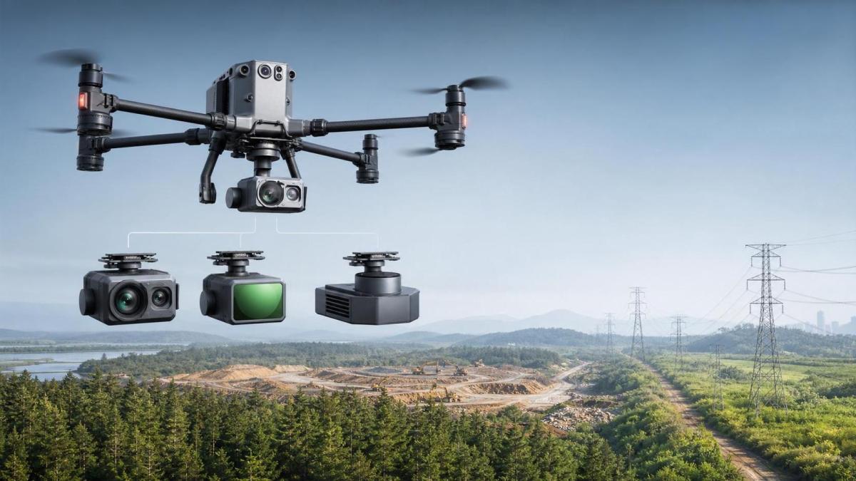
Camera Payloads: Best for Cost Efficiency and Visual Detail
Camera-based payloads remain the most common entry point among commercial UAV payload options.
They are usually lighter, cheaper, and easier to integrate into standard drone workflows.
For orthomosaics, facade inspection, site progress tracking, and basic topographic outputs, they are often sufficient.
Their strongest advantage is visual richness.
High-resolution imagery supports defect review, client communication, and straightforward archive management.
That makes camera payloads attractive when operational teams need evidence that is easy to interpret.
Where Cameras Work Well
- Construction progress monitoring and as-built documentation.
- Roof, tower, and solar inspections with visible defect cues.
- Agriculture missions using RGB or multispectral imaging.
- Lower-budget mapping programs with frequent repeat flights.
Main Limits
Image-based mapping depends heavily on light, texture, and overlap quality.
Dense vegetation, reflective surfaces, and low-contrast terrain can reduce output reliability.
Photogrammetry also struggles to represent ground beneath canopy.
So while camera systems rank well in many commercial UAV payload options reviews, they are not universally fit.
LiDAR Payloads: Strongest for Terrain Accuracy and Vegetation Penetration
LiDAR sits at the premium end of commercial UAV payload options for a reason.
It produces 3D point clouds directly, reducing dependence on surface texture and ambient light.
For forestry, utilities, mining, and engineering-grade terrain work, this can be a decisive advantage.
The key business value is not novelty.
It is repeatable geometry in conditions where cameras lose confidence.
LiDAR can also shorten field revisits when the original mission already captured enough spatial detail.
Where LiDAR Delivers Clear ROI
- Topographic mapping under canopy or brush cover.
- Transmission corridor and rail route modeling.
- Stockpile volume measurement with complex geometry.
- Floodplain, drainage, and civil planning surveys.
Main Limits
LiDAR raises acquisition cost, calibration requirements, and processing complexity.
Payload weight can reduce endurance or require a larger aircraft.
Teams also need to validate IMU performance, GNSS quality, and point cloud workflows.
That means LiDAR wins only when the mission truly benefits from its depth.
Mapping Sensors: The Middle Ground Across Commercial UAV Payload Options
The term mapping sensors covers a broad set of payloads.
It may include metric cameras, multispectral units, thermal imagers, and integrated survey packages.
In many cases, these commercial UAV payload options serve organizations that need more than visual inspection, but less than full LiDAR capability.
This category is often the most misunderstood because specifications vary widely.
Some deliver improved geometric fidelity for surveying.
Others unlock crop health, thermal leakage, or material condition analysis.
Why This Category Matters
These sensors can improve decision quality without carrying LiDAR-level cost and data burden.
They also support application-specific workflows that a standard RGB camera cannot cover well.
For example, thermal mapping may reveal insulation loss or panel hotspots that visual imagery misses.
Multispectral mapping may detect stress signals before they become visible in crops.
A Practical Comparison of Camera, LiDAR, and Mapping Sensor Trade-Offs
This comparison shows why commercial UAV payload options should be scored against actual deliverables, not generic labels.
How to Evaluate Commercial UAV Payload Options for Procurement
A sound evaluation process starts with the output requirement.
Define the final dataset, tolerance, reporting format, and update frequency before reviewing vendors.
That step alone prevents many costly misalignments.
Use This Checklist
- Match payload type to mission environment, not vendor positioning.
- Verify ground sampling distance, point density, and georeferencing method.
- Review payload weight against flight endurance and wind tolerance.
- Check software compatibility, export formats, and post-processing labor.
- Estimate lifecycle cost, including calibration, training, and sensor downtime.
- Request sample datasets from comparable sites, not demo-friendly terrain only.
This is where many commercial UAV payload options look different on paper than in deployment.
Common Buying Mistakes and How to Avoid Them
One common mistake is paying for maximum capability when repeatability is the real requirement.
Another is selecting the payload first and discovering later that software, aircraft, and training costs were underestimated.
A third mistake is trusting broad accuracy claims without asking how they were measured.
The better approach is to test commercial UAV payload options against a representative pilot mission.
Use the same site conditions, processing workflow, and acceptance criteria planned for production.
That gives a realistic basis for cost, speed, and data quality comparisons.
Which Commercial UAV Payload Options Fit Which Mission?
If the goal is clear visual evidence at scale, camera payloads are usually the strongest fit.
If terrain accuracy under vegetation matters most, LiDAR is typically the right investment.
If the mission depends on thermal, crop, or material intelligence, mapping sensors often provide the best balance.
The broader point is simple.
The best commercial UAV payload options are the ones that reduce uncertainty in the decision that follows the flight.
That means evaluating sensors through engineering outcomes, workflow burden, and total operational value.
For teams that want cleaner procurement logic, that is the standard worth using.
Search News
Hot Articles
- Carbon Fiber StructuresHow to Specify Aerospace Carbon Fiber Assemblies for Lightweight, Load-Bearing PartsJul 11, 2026
- Machine VisionXiaomi, Alibaba DAMO Academy Drive Open-Source Robotics Model Ecosystem, Lowering Algorithm Development Barriers for Overseas SMEs Adopting Chinese Robotics SolutionsMar 30, 2026
- Cobots & ArmsShanxi 'AI+' Conference Showcases Embodied Intelligence with Multinational Buyer Engagement: Key Industry ImplicationsMar 30, 2026
Popular Tags
Recommended News
 Jul 11, 2026How to Specify Aerospace Carbon Fiber Assemblies for Lightweight, Load-Bearing PartsAerospace carbon fiber assemblies: learn how to specify laminate design, load data, joining methods, and inspection controls for lighter, reliable load-bearing aerospace parts.Elena Rostova (UAV Systems Researcher)
 Mar 30, 2026Xiaomi, Alibaba DAMO Academy Drive Open-Source Robotics Model Ecosystem, Lowering Algorithm Development Barriers for Overseas SMEs Adopting Chinese Robotics SolutionsXiaomi & Alibaba DAMO Academy's open-source robotics models lower algorithm barriers for global SMEs. Boost efficiency in manufacturing, logistics & smart retail with ROS 2 compatible solutions.TSV Data Lab
 Mar 30, 2026Shanxi 'AI+' Conference Showcases Embodied Intelligence with Multinational Buyer Engagement: Key Industry ImplicationsShanxi 'AI+' Conference highlights embodied intelligence with Tesla, Ubtech & Jiantao showcasing multimodal robotics. 40+ global buyers validated tech on-site, creating new B2B channels for industrial automation & AI solutions.Chen Wei (Automation Lead Engineer)
 Mar 30, 2026Zhongguancun Unveils 6G Integrated Sensing-Computing-Intelligence Platform to Empower Embodied Robots for Global Industrial ApplicationsZhongguancun's new 6G platform revolutionizes industrial robotics with <10ms latency, empowering global automotive, logistics & port automation. Discover how this tech boosts China's smart manufacturing exports.TSV Data Lab
 Mar 30, 2026Mech-Mind Tianjin Embodied Intelligence R&D and Production Base Goes Live, Cutting Delivery Time by 20%–30% for Global Customized AMR+Vision SolutionsMech-Mind's Tianjin AMR+Vision production base cuts delivery time by 20%-30% for欧美 & Latin American markets. Discover how this PLd-certified facility accelerates customized robotics solutions for smart manufacturing and logistics.Chen Wei (Automation Lead Engineer)
 Mar 30, 2026Boao Forum Reveals 'Co-evolution of Big and Small Brains' Trend in Humanoid Robots, China's Embodied Intelligence Accelerates Adaptation to Overseas Manufacturing Service ScenariosDiscover how China's humanoid robots, featuring 'Co-evolution of Big and Small Brains,' are revolutionizing global manufacturing. Learn about Embodied Tian Gong 3.0's ISO compliance and overseas deployment at Boao Forum 2026.Chen Wei (Automation Lead Engineer)
 Mar 30, 2026China Railway Industrial Secures Patent for Embodied Robotics in Material Handling, Boosting High-Precision Delivery Capabilities for Overseas Infrastructure and Manufacturing ProjectsChina Railway Industrial's new patent for embodied robotics in material handling boosts high-precision delivery for global infrastructure & manufacturing. Discover how this innovation enhances logistics accuracy in automotive, rail transit & EPC projects.Chen Wei (Automation Lead Engineer)
 Oct 06, 2026Navigation Fault Tolerance Standards for AMRs: What Safety Teams Must VerifyNavigation fault tolerance standards: learn what AMR safety teams must verify, from localization loss and sensor faults to stopping distance, safe restart, and site-specific validation.Chen Wei (Automation Lead Engineer)
 Oct 05, 2026Calculating Edge Computing Total Cost of Ownership Across Distributed SitesEdge computing ownership cost explained: calculate deployment, energy, connectivity, security, remote support, and refresh costs across distributed sites.TSV Data Lab
 Oct 04, 2026CAD/CAM Benchmarking in the GCC: What Manufacturers Should Ask a ConsultantCAD CAM benchmark consultant GCC guide: learn the key questions manufacturers should ask to validate post-processors, workflows, machine performance, and production risk.Victor Lin (Chief Software Architect)
 Oct 03, 2026Selecting Automotive Radar Sensor Modules for ADAS Range, Resolution, and IntegrationAutomotive radar sensor module selection guide for ADAS: compare range, resolution, field of view, latency, and integration to build safer, reliable vehicle systems.TSV Data Lab
 Oct 02, 2026How to Qualify Machined Parts Suppliers for Hard Tech ProgramsHard tech supply chain machined parts demand rigorous supplier qualification. Learn how to assess capability, traceability, quality controls, and delivery resilience.Dr. Marcus Vance
 Oct 01, 2026How to Select an Outdoor Security Radar Sensor for Perimeter Detection?Outdoor security radar sensor selection guide: compare range, accuracy, false-alarm control, integration, and field testing for reliable perimeter detection.TSV Data Lab
 Sep 30, 2026How to Evaluate Solid-State LiDAR Hardware for Outdoor Autonomous VehiclesSolid state LiDAR hardware evaluation guide for outdoor autonomous vehicles—compare range, point-cloud quality, environmental resilience, integration, and safety.TSV Data Lab
 Sep 29, 2026ISO 9283 Repeatability: How to Evaluate Cobot Positioning PerformanceISO 9283 cobot repeatability explained: learn how payload, reach, approach direction, and test conditions affect positioning performance and cell capability.Chen Wei (Automation Lead Engineer)
 Oct 06, 2026Are Collaborative Robots Safe Enough to Operate Without Fencing?Are collaborative robots safe enough to work without fencing? Explore risk assessment, safeguarding options, and practical guidance for safer, productive cobot cells.Chen Wei (Automation Lead Engineer)
 Oct 05, 2026What Causes Machine Vision Systems to Miss Small Defects?What causes machine vision systems to miss small defects? Discover how lighting, optics, motion, and AI thresholds affect detection—and prevent costly escapes.TSV Data Lab
 Oct 04, 2026How Should You Compare 5-Axis CNC Machine Accuracy Claims?How do I compare 5-axis CNC machine accuracy claims? Learn how to assess standards, thermal stability, TCP accuracy, and real-world test evidence.Dr. Marcus Vance
 Oct 03, 2026Is Edge Computing Necessary for Real-Time Quality Inspection?Is industrial edge computing necessary for real-time quality inspection? Explore how latency, data volume, reliability, and control integration shape the right architecture.TSV Data Lab
 Oct 02, 2026What Documents Prove a Precision Machining Supplier Can Hold Tolerance?What documents prove a precision machining supplier can hold tolerance? Explore certificates, FAI reports, calibration, SPC, and traceability evidence to qualify suppliers with confidence.Dr. Marcus Vance
 Oct 01, 2026Can a Machining Supplier Meet Aerospace Fatigue Testing Requirements?Can a machining supplier meet aerospace fatigue testing requirements? Learn the traceability, process control, and test evidence needed for reliable aerospace parts.Dr. Marcus Vance
 Sep 30, 2026Which Industrial Robot Specifications Matter for High-Precision Assembly?Which industrial robot specifications matter most for high-precision assembly? Explore repeatability, accuracy, stiffness, vibration, calibration, and force control for reliable yields.Chen Wei (Automation Lead Engineer)
 Sep 29, 2026How Do You Verify Servo Motor Torque Under Continuous Load?How do I verify servo motor torque under continuous load? Learn RMS torque checks, torque-speed limits, thermal derating, and real-machine testing.Chen Wei (Automation Lead Engineer)
 Oct 02, 2026ZD330 Software Configuration: Verifying Cut-List Import Before PurchaseZD330 software and machine configuration: verify cut-list imports, data mapping, labels, and workflow before purchase to reduce errors and choose with confidence.Victor Lin (Chief Software Architect)