How accurate is solid-state LiDAR range accuracy in rain?
Publication Date
author
In autonomous systems, weather resilience is not a marketing claim—it is a procurement variable. When evaluating solid-state LiDAR range accuracy in rain, enterprise buyers need more than nominal specs; they need insight into signal attenuation, point cloud stability, and real-world detection thresholds. This article examines how rain affects performance, what engineering parameters matter most, and how decision-makers can benchmark sensor reliability with data-driven confidence.
Why does rain change solid-state LiDAR range accuracy so much in procurement testing?
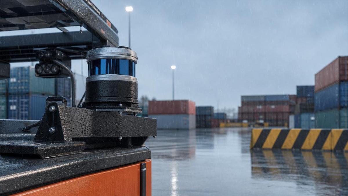
Solid-state LiDAR range accuracy is usually presented under controlled laboratory conditions. Rain introduces a very different optical environment. Water droplets scatter, absorb, and redirect emitted light pulses, which reduces return signal strength and increases false echoes.
For enterprise decision-makers, the question is not whether rain affects performance. It does. The real question is how far the degradation extends, under what rainfall intensity, and whether the sensor still meets operational safety margins.
This matters across robotics, UAV navigation, perimeter monitoring, mining vehicles, smart infrastructure, and industrial edge AI systems. A sensor that performs well on a sunny demo track may fail procurement expectations in a port, warehouse yard, agricultural field, or roadside deployment.
- Rain reduces usable detection range by weakening the reflected signal from low-reflectivity targets.
- Droplets create backscatter that can generate noisy points and unstable object contours.
- The impact is highly dependent on wavelength, beam divergence, processing algorithms, and target reflectance.
- Published maximum range values often do not describe rain performance at fleet-operational thresholds.
What “range accuracy” means in real deployments
Buyers often conflate three different metrics: absolute distance error, maximum detection range, and point cloud consistency. In rain, all three may deteriorate, but not at the same rate. One sensor may keep acceptable distance error while losing target continuity. Another may keep point density but shorten usable range.
That is why TechStat Vanguard emphasizes engineering truth over headline numbers. A procurement-grade evaluation should ask: at a defined rainfall rate, target reflectivity, and vehicle speed, what is the minimum detection distance at which the system still supports braking, navigation, or classification decisions?
Which engineering parameters matter most for solid-state LiDAR range accuracy in rain?
Rain performance should be broken into measurable parameters, not generic claims. The table below highlights the variables procurement teams should request during technical clarification and supplier comparison.
The key insight is that solid-state LiDAR range accuracy in rain is not dictated by optics alone. It is the result of an optical-electronic-software chain. A supplier that shares only maximum range and frame rate is withholding the metrics that matter most in field reliability.
Do not ignore target reflectivity
Rain penalties are much worse for dark rubber, wet asphalt, low-contrast debris, and matte-painted equipment than for reflective calibration boards. If your operating environment includes black tires, pallet edges, cables, vegetation, or non-uniform road surfaces, request test data on low-reflectance objects.
How should enterprise teams benchmark rain performance across application scenarios?
A meaningful benchmark must connect sensor output to mission outcome. The same level of range degradation has different implications for low-speed warehouse AMRs, highway-adjacent roadside systems, or commercial UAV obstacle sensing.
Scenario-specific risk profile
- Industrial vehicles and mobile robots need stable obstacle contours more than long headline range. Stop distance and false positives are the critical outputs.
- UAVs need rapid update rates and robust near-field detection because rain can disrupt both attitude control confidence and obstacle perception margins.
- Smart infrastructure and security systems need continuity over long unattended periods, which makes lens contamination, drainage design, and maintenance cycles as important as nominal accuracy.
- Mining, agriculture, and outdoor logistics require tolerance to mud, spray, and mixed precipitation, not just clean vertical rainfall.
The following table helps procurement leaders translate solid-state LiDAR range accuracy into application-specific acceptance criteria.
A strong benchmark plan starts with operational design domain, not with brochure specifications. TSV’s engineering view is simple: define the task, define the threshold, then test the sensor against that threshold under weather stress.
What do buyers often miss when comparing solid-state LiDAR against alternative sensing stacks?
Rain rarely affects one sensor category in isolation. Procurement teams should compare solid-state LiDAR with cameras, millimeter-wave radar, and fused architectures because range accuracy is only one part of system reliability.
Comparison logic that supports board-level decisions
LiDAR provides direct depth measurement and strong geometric detail. Cameras provide semantic richness but degrade under darkness, glare, and water droplets on lenses. Radar is resilient in adverse weather but offers lower spatial resolution. In rain, many enterprises reach better outcomes with complementary sensing rather than a single-sensor strategy.
- If your system must classify small objects precisely, LiDAR remains valuable even when rain reduces long-range performance.
- If your system must maintain detection in heavy precipitation at long distances, radar may carry the primary weather-resilience role.
- If budget, power, and compute are constrained, a carefully specified LiDAR-plus-camera stack may outperform an overengineered multi-radar architecture.
Cost is not only hardware price
A cheaper unit with weak solid-state LiDAR range accuracy in rain can increase downstream costs through integration delays, extra validation cycles, safety redesign, and field service interventions. For enterprise programs, total cost of ownership should include weather validation, cleaning strategy, spare policy, and software tuning effort.
How should procurement teams write a better specification for rain testing?
Many procurement documents ask for “all-weather operation” without defining acceptance criteria. That phrase is too vague to protect technical and commercial interests. A better RFQ or supplier qualification pack should specify test conditions, target types, and pass-fail logic.
Recommended procurement checklist
- Define rainfall categories for validation, such as light rain, moderate rain, and heavy rain, based on your operating geography and duty cycle.
- Specify target reflectivity classes, including low-reflectance objects that mirror your actual environment.
- Request both raw point cloud samples and post-processed outputs so algorithmic filtering can be assessed transparently.
- Ask for distance error, probability of detection, false alarm behavior, and point density at each relevant range band.
- Include contamination and drainage considerations, especially for enclosures exposed to splash, condensation, or road film.
- Tie sensor acceptance to system-level outcomes such as stopping distance, navigation uptime, or intervention rate.
This method reduces the information noise that often delays supplier selection. It also aligns with TSV’s position that parameters and tolerances should govern sourcing decisions, not broad claims made in demos or marketing sheets.
Which standards and compliance topics should enterprises review?
There is no single universal certificate that proves solid-state LiDAR range accuracy in rain. However, buyers should still review adjacent compliance and validation topics because they influence deployment readiness and qualification cost.
- Ingress protection ratings help indicate enclosure resistance to water and dust but do not prove maintained sensing performance during rainfall.
- Environmental test practices for temperature, vibration, and humidity matter because wet-weather use often coincides with thermal and mechanical stress.
- Functional safety and system safety frameworks should be reviewed if LiDAR data influences braking, collision avoidance, or protected-zone control.
- Electromagnetic compatibility remains relevant when LiDAR is integrated with edge compute modules, radios, and vehicle power electronics.
The practical lesson is clear: compliance documents support due diligence, but they do not replace application-specific weather testing. Buyers should treat them as part of a broader validation stack.
FAQ: what do decision-makers ask most about solid-state LiDAR range accuracy in rain?
Does rain make solid-state LiDAR unusable?
No. In many applications it remains usable, but performance degrades according to rainfall intensity, target material, lens condition, and processing quality. The right question is whether degraded performance still satisfies the mission threshold.
Is longer advertised range a reliable indicator of better rain performance?
Not necessarily. Some sensors advertise impressive dry-weather range but lose practical reliability quickly in rain because filtering, receiver control, or target reflectivity assumptions are weak. Rain validation data is more valuable than a single maximum-range line item.
Should procurement teams require field testing instead of lab reports?
They should require both. Lab reports provide repeatability and baseline comparison. Field tests reveal contamination, clutter, mounting issues, and site-specific effects such as spray, reflective surfaces, and mixed weather. Together they support defensible sourcing decisions.
How much detail should suppliers provide?
Enough to let your technical team reproduce the evaluation logic. That usually means rainfall condition, target specification, range band, reflectivity assumption, point cloud snapshots, and post-processing method. If these are absent, the range claim is hard to audit.
Why work with a data-driven benchmarking partner before final supplier selection?
For high-value sensing programs, the biggest risk is often not choosing the worst sensor. It is choosing on incomplete evidence. TechStat Vanguard focuses on reducing that risk by filtering out vague claims and centering procurement on measurable engineering truth.
For teams evaluating solid-state LiDAR range accuracy in rain, that means clarifying test parameters, benchmarking competing architectures, and identifying where specification gaps could create cost, safety, or schedule exposure later in the project.
Why choose us
TSV supports enterprise decision-makers who need more than catalog data. You can consult with us on parameter confirmation, rain-test evaluation logic, supplier comparison criteria, detection-threshold planning, integration risk review, and application-specific benchmark design.
If you are preparing an RFQ, validating a new sensor stack, or shortening a supplier qualification cycle, contact us to discuss target specifications, delivery timing assumptions, custom benchmarking scope, compliance considerations, sample evaluation priorities, and quote-stage technical communication.
Search News
Hot Articles
- Carbon Fiber StructuresHow to Specify Aerospace Carbon Fiber Assemblies for Lightweight, Load-Bearing PartsJul 11, 2026
- Machine VisionXiaomi, Alibaba DAMO Academy Drive Open-Source Robotics Model Ecosystem, Lowering Algorithm Development Barriers for Overseas SMEs Adopting Chinese Robotics SolutionsMar 30, 2026
- Cobots & ArmsShanxi 'AI+' Conference Showcases Embodied Intelligence with Multinational Buyer Engagement: Key Industry ImplicationsMar 30, 2026
Popular Tags
Recommended News
 Jul 11, 2026How to Specify Aerospace Carbon Fiber Assemblies for Lightweight, Load-Bearing PartsAerospace carbon fiber assemblies: learn how to specify laminate design, load data, joining methods, and inspection controls for lighter, reliable load-bearing aerospace parts.Elena Rostova (UAV Systems Researcher)
 Mar 30, 2026Xiaomi, Alibaba DAMO Academy Drive Open-Source Robotics Model Ecosystem, Lowering Algorithm Development Barriers for Overseas SMEs Adopting Chinese Robotics SolutionsXiaomi & Alibaba DAMO Academy's open-source robotics models lower algorithm barriers for global SMEs. Boost efficiency in manufacturing, logistics & smart retail with ROS 2 compatible solutions.TSV Data Lab
 Mar 30, 2026Shanxi 'AI+' Conference Showcases Embodied Intelligence with Multinational Buyer Engagement: Key Industry ImplicationsShanxi 'AI+' Conference highlights embodied intelligence with Tesla, Ubtech & Jiantao showcasing multimodal robotics. 40+ global buyers validated tech on-site, creating new B2B channels for industrial automation & AI solutions.Chen Wei (Automation Lead Engineer)
 Mar 30, 2026Zhongguancun Unveils 6G Integrated Sensing-Computing-Intelligence Platform to Empower Embodied Robots for Global Industrial ApplicationsZhongguancun's new 6G platform revolutionizes industrial robotics with <10ms latency, empowering global automotive, logistics & port automation. Discover how this tech boosts China's smart manufacturing exports.TSV Data Lab
 Mar 30, 2026Mech-Mind Tianjin Embodied Intelligence R&D and Production Base Goes Live, Cutting Delivery Time by 20%–30% for Global Customized AMR+Vision SolutionsMech-Mind's Tianjin AMR+Vision production base cuts delivery time by 20%-30% for欧美 & Latin American markets. Discover how this PLd-certified facility accelerates customized robotics solutions for smart manufacturing and logistics.Chen Wei (Automation Lead Engineer)
 Mar 30, 2026Boao Forum Reveals 'Co-evolution of Big and Small Brains' Trend in Humanoid Robots, China's Embodied Intelligence Accelerates Adaptation to Overseas Manufacturing Service ScenariosDiscover how China's humanoid robots, featuring 'Co-evolution of Big and Small Brains,' are revolutionizing global manufacturing. Learn about Embodied Tian Gong 3.0's ISO compliance and overseas deployment at Boao Forum 2026.Chen Wei (Automation Lead Engineer)
 Mar 30, 2026China Railway Industrial Secures Patent for Embodied Robotics in Material Handling, Boosting High-Precision Delivery Capabilities for Overseas Infrastructure and Manufacturing ProjectsChina Railway Industrial's new patent for embodied robotics in material handling boosts high-precision delivery for global infrastructure & manufacturing. Discover how this innovation enhances logistics accuracy in automotive, rail transit & EPC projects.Chen Wei (Automation Lead Engineer)
 Oct 06, 2026Navigation Fault Tolerance Standards for AMRs: What Safety Teams Must VerifyNavigation fault tolerance standards: learn what AMR safety teams must verify, from localization loss and sensor faults to stopping distance, safe restart, and site-specific validation.Chen Wei (Automation Lead Engineer)
 Oct 05, 2026Calculating Edge Computing Total Cost of Ownership Across Distributed SitesEdge computing ownership cost explained: calculate deployment, energy, connectivity, security, remote support, and refresh costs across distributed sites.TSV Data Lab
 Oct 04, 2026CAD/CAM Benchmarking in the GCC: What Manufacturers Should Ask a ConsultantCAD CAM benchmark consultant GCC guide: learn the key questions manufacturers should ask to validate post-processors, workflows, machine performance, and production risk.Victor Lin (Chief Software Architect)
 Oct 03, 2026Selecting Automotive Radar Sensor Modules for ADAS Range, Resolution, and IntegrationAutomotive radar sensor module selection guide for ADAS: compare range, resolution, field of view, latency, and integration to build safer, reliable vehicle systems.TSV Data Lab
 Oct 02, 2026How to Qualify Machined Parts Suppliers for Hard Tech ProgramsHard tech supply chain machined parts demand rigorous supplier qualification. Learn how to assess capability, traceability, quality controls, and delivery resilience.Dr. Marcus Vance
 Oct 01, 2026How to Select an Outdoor Security Radar Sensor for Perimeter Detection?Outdoor security radar sensor selection guide: compare range, accuracy, false-alarm control, integration, and field testing for reliable perimeter detection.TSV Data Lab
 Sep 30, 2026How to Evaluate Solid-State LiDAR Hardware for Outdoor Autonomous VehiclesSolid state LiDAR hardware evaluation guide for outdoor autonomous vehicles—compare range, point-cloud quality, environmental resilience, integration, and safety.TSV Data Lab
 Sep 29, 2026ISO 9283 Repeatability: How to Evaluate Cobot Positioning PerformanceISO 9283 cobot repeatability explained: learn how payload, reach, approach direction, and test conditions affect positioning performance and cell capability.Chen Wei (Automation Lead Engineer)
 Oct 06, 2026Are Collaborative Robots Safe Enough to Operate Without Fencing?Are collaborative robots safe enough to work without fencing? Explore risk assessment, safeguarding options, and practical guidance for safer, productive cobot cells.Chen Wei (Automation Lead Engineer)
 Oct 05, 2026What Causes Machine Vision Systems to Miss Small Defects?What causes machine vision systems to miss small defects? Discover how lighting, optics, motion, and AI thresholds affect detection—and prevent costly escapes.TSV Data Lab
 Oct 04, 2026How Should You Compare 5-Axis CNC Machine Accuracy Claims?How do I compare 5-axis CNC machine accuracy claims? Learn how to assess standards, thermal stability, TCP accuracy, and real-world test evidence.Dr. Marcus Vance
 Oct 03, 2026Is Edge Computing Necessary for Real-Time Quality Inspection?Is industrial edge computing necessary for real-time quality inspection? Explore how latency, data volume, reliability, and control integration shape the right architecture.TSV Data Lab
 Oct 02, 2026What Documents Prove a Precision Machining Supplier Can Hold Tolerance?What documents prove a precision machining supplier can hold tolerance? Explore certificates, FAI reports, calibration, SPC, and traceability evidence to qualify suppliers with confidence.Dr. Marcus Vance
 Oct 01, 2026Can a Machining Supplier Meet Aerospace Fatigue Testing Requirements?Can a machining supplier meet aerospace fatigue testing requirements? Learn the traceability, process control, and test evidence needed for reliable aerospace parts.Dr. Marcus Vance
 Sep 30, 2026Which Industrial Robot Specifications Matter for High-Precision Assembly?Which industrial robot specifications matter most for high-precision assembly? Explore repeatability, accuracy, stiffness, vibration, calibration, and force control for reliable yields.Chen Wei (Automation Lead Engineer)
 Sep 29, 2026How Do You Verify Servo Motor Torque Under Continuous Load?How do I verify servo motor torque under continuous load? Learn RMS torque checks, torque-speed limits, thermal derating, and real-machine testing.Chen Wei (Automation Lead Engineer)
 Oct 02, 2026ZD330 Software Configuration: Verifying Cut-List Import Before PurchaseZD330 software and machine configuration: verify cut-list imports, data mapping, labels, and workflow before purchase to reduce errors and choose with confidence.Victor Lin (Chief Software Architect)