Drone photogrammetry software integration fails for predictable reasons
Publication Date
author
When drone photogrammetry software integration fails, the root cause is usually not the mapping engine alone. In most deployments, breakdowns happen because teams connect incompatible sensors, weak GNSS/IMU data, unstable communications, inconsistent file formats, and poorly defined workflows—then expect the software layer to compensate. That rarely works. For operators running a custom drone for power line inspection, buyers evaluating platforms for uav lidar for topographical survey, or asset owners planning uav thermal inspection solar panels, the practical lesson is simple: integration problems are predictable, measurable, and often avoidable before purchase.
For technical teams, this means validating the full data chain instead of benchmarking software in isolation. For procurement and decision-makers, it means asking whether the stack—airframe, payload, positioning, mission planning, processing engine, storage, and uav fleet management system—was designed to work together under field conditions. The organizations that avoid expensive rework are usually the ones that treat integration as a systems engineering problem from day one.
Why drone photogrammetry software integration fails in the same ways again and again
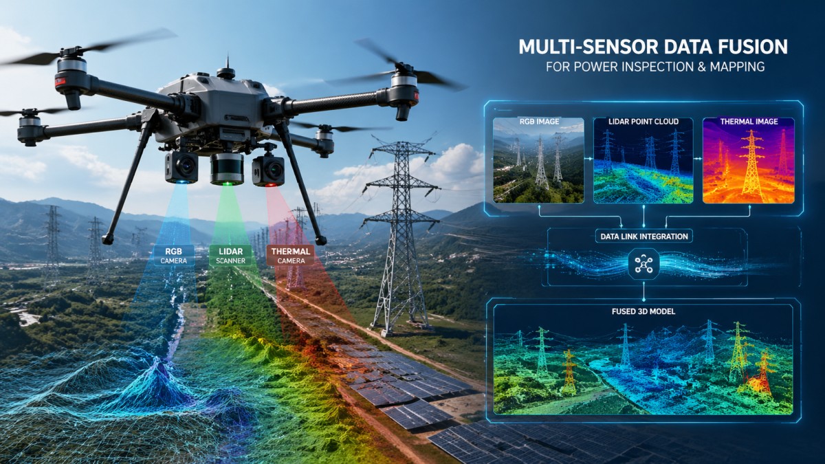
The most common failures are surprisingly repeatable because they come from the same categories of mismatch:
- Sensor-to-software mismatch: Camera models, shutter types, focal calibration, LiDAR timing, and thermal payload metadata are not always fully supported by the processing stack.
- Weak georeferencing inputs: Poor GNSS quality, drifting IMU data, or inconsistent RTK/PPK workflows degrade accuracy long before data reaches the software.
- Mission planning errors: Inadequate overlap, wrong speed, bad altitude choice, poor lighting windows, or flight paths unsuited to the inspection task create unusable datasets.
- Interoperability gaps: The photogrammetry platform may process imagery well, but fail to exchange data cleanly with CAD, GIS, asset management, or a uav fleet management system.
- Compute and storage bottlenecks: Large orthomosaics, dense point clouds, and multi-sensor datasets overwhelm local hardware, network throughput, or cloud transfer pipelines.
- Operational inconsistency: Different crews capture data differently, naming conventions vary, calibration routines are skipped, and quality assurance becomes subjective.
In other words, “software integration failure” is often a label for a system that was never tightly specified. The software simply becomes the visible point where hidden upstream errors finally surface.
What operators, buyers, and decision-makers actually need to know before rollout
Searchers looking into drone photogrammetry software integration are rarely asking a theoretical question. They usually want one of four answers:
- Why is our current workflow unstable?
- How do we evaluate software and hardware compatibility before procurement?
- What causes accuracy, processing, or export problems in real projects?
- How can we reduce implementation risk across inspection, survey, and enterprise operations?
That means the useful evaluation criteria are not marketing claims such as “AI-powered” or “survey-grade ready.” The useful questions are more concrete:
- Which camera and sensor models are natively supported?
- How is lens calibration handled and stored?
- Does the workflow support RTK, PPK, ground control points, or all three?
- What export formats are available for GIS, BIM, CAD, and asset platforms?
- Can the software ingest thermal, RGB, LiDAR, and multispectral datasets in one project?
- How well does it connect with a uav fleet management system for mission records, compliance, and operator traceability?
- What is the actual processing time per gigabyte or per square kilometer on known hardware?
- What failure alerts exist for blur, insufficient overlap, geotag loss, or calibration drift?
These are the questions that matter because they determine whether the platform performs consistently outside a demo environment.
The biggest technical causes of integration underperformance
1. Inconsistent sensor metadata
Photogrammetry depends heavily on clean metadata. If timestamps are inconsistent, camera parameters are wrong, coordinate reference systems are mixed, or thermal payloads store proprietary tags that the software interprets poorly, reconstruction quality drops quickly. This is especially common when organizations build mixed fleets over time rather than standardizing equipment.
2. Positioning quality that looks acceptable but is not
Many teams assume having RTK means accuracy is solved. It is not. Antenna placement, correction service stability, multipath interference, IMU synchronization, and base station workflow discipline all affect final model reliability. In power corridor or industrial site environments, electromagnetic noise and reflective structures can create subtle but serious errors.
3. Payload-airframe combinations that were never optimized together
A custom drone for power line inspection may fly well, but that does not guarantee image geometry, vibration isolation, gimbal control, or timing synchronization are suitable for photogrammetric reconstruction. The airframe may be excellent for visual inspection and still perform poorly for precise 3D mapping.
4. Workflows mixing LiDAR expectations with photogrammetry limitations
Teams adopting uav lidar for topographical survey sometimes expect photogrammetry software to handle vegetation penetration, terrain classification, and dense elevation modeling in the same way as dedicated LiDAR processing environments. But the data logic differs. If software integration is designed without recognizing those differences, outputs disappoint users even when each individual component is functioning correctly.
5. Thermal inspection use cases treated like RGB mapping jobs
For uav thermal inspection solar panels, the workflow must account for temperature calibration, emissivity, inspection timing, irradiance conditions, and thermal anomaly interpretation. A photogrammetry engine may stitch thermal imagery, but if the integration does not preserve radiometric integrity or inspection context, the result may look complete while being operationally weak.
Why interoperability with a uav fleet management system often becomes the hidden bottleneck
Many organizations discover too late that image processing is only one part of enterprise deployment. Once multiple pilots, sites, aircraft, and recurring missions are involved, integration with a uav fleet management system becomes critical.
The failure patterns here are predictable:
- Flight logs and processed outputs are stored in separate silos.
- Mission IDs do not match inspection records or asset IDs.
- Maintenance status and payload calibration history are disconnected from dataset quality reviews.
- Regulatory documentation, operator credentials, and project metadata cannot be linked to final deliverables.
- Cloud APIs are available in theory but weak in practice, requiring manual exports and spreadsheet reconciliation.
For a field operator, that creates rework. For procurement, it creates hidden labor cost. For enterprise leadership, it weakens traceability and audit readiness. If the software cannot connect missions, aircraft health, operator actions, and output datasets into one usable chain of custody, the deployment will struggle to scale.
How to evaluate integration risk before procurement
The best time to prevent failure is before contract signature. A strong evaluation process should include the following checks:
- Compatibility matrix: Verify exact support for cameras, LiDAR units, thermal sensors, GNSS modules, and export standards—not just generic device categories.
- Reference workflow test: Run one real project from capture to final deliverable, including upload, processing, QA, export, and archival.
- Accuracy verification: Measure horizontal and vertical error against known control, not vendor screenshots.
- Failure mode review: Test what happens when overlap drops, GNSS tags are incomplete, or connection is interrupted mid-transfer.
- API and integration review: Confirm whether integration with GIS, ERP, CMMS, digital twin, and uav fleet management system platforms is native, documented, and actually maintainable.
- Total cost modeling: Include licenses, cloud compute, training, storage, bandwidth, support, calibration, and field retakes.
- Role-based usability: Evaluate separately for pilot, analyst, GIS specialist, maintenance planner, and executive reviewer.
This approach is far more useful than comparing vendors on feature count alone. Integration success comes from workflow fit, not checkbox volume.
Use-case differences matter more than many teams expect
One reason integration fails is that organizations treat all drone data pipelines as interchangeable. They are not.
For uav lidar for topographical survey, the priority is often terrain fidelity, vegetation handling, classification workflow, coordinate rigor, and downstream compatibility with civil engineering tools. Here, the question is not just whether the software “supports LiDAR,” but whether it supports the point density, classification rules, strip alignment, and geodetic controls the survey team actually needs.
For a custom drone for power line inspection, the priority may be corridor capture consistency, conductor visibility, tower geometry, geolocation confidence, and integration with utility asset systems. In this environment, vibration, wind performance, zoom payload coordination, and repeatable route planning may matter more than generic mapping features.
For uav thermal inspection solar panels, the priority is defect detection quality, temporal consistency, radiometric validity, and reporting workflow. If the platform creates visually appealing maps but weak anomaly classification or poor export into maintenance systems, the integration has not really succeeded.
The lesson is simple: software should be evaluated against the operating objective, not against abstract “drone mapping” claims.
How high-performing teams reduce integration failure in practice
Organizations that deploy successfully usually do five things well:
- They standardize hardware where possible. Mixed fleets are sometimes necessary, but unnecessary variation in sensors and metadata formats creates avoidable complexity.
- They define a controlled data pipeline. File naming, coordinate systems, calibration storage, operator checklists, and QA thresholds are documented and enforced.
- They validate field capture before leaving site. Quick checks for overlap, exposure, geotag integrity, and sample reconstruction reduce costly return visits.
- They separate pilot convenience from enterprise fit. Easy flying does not guarantee scalable data operations.
- They require proof with real datasets. Vendors should process representative jobs from your environment, not only ideal demo scenes.
This is particularly important for buyers under pressure to launch quickly. Fast rollout without systems validation often increases the total deployment timeline because rework, retraining, and integration fixes arrive later.
A practical decision framework for procurement and technical leadership
If your organization is choosing or replacing drone photogrammetry software, use this simple decision lens:
- Can it ingest our real sensors reliably?
- Can it preserve the accuracy level our deliverables require?
- Can it connect to our uav fleet management system and business software without manual workarounds?
- Can field teams use it consistently under operational pressure?
- Can we quantify processing time, labor demand, and retake risk?
- Can the vendor show evidence from similar use cases, not adjacent ones?
If the answer to any of these is uncertain, the integration risk is real. And in most cases, that risk is more predictive of project success than the software’s headline feature list.
Conclusion
Drone photogrammetry software integration fails for predictable reasons because the failure usually begins upstream—in sensor choice, georeferencing quality, workflow design, interoperability planning, and operational discipline. The software is only one layer in a larger engineering system. Teams that recognize this early make better procurement decisions, reduce retakes, shorten qualification cycles, and build data pipelines that actually scale.
For organizations comparing solutions across uav lidar for topographical survey, custom drone for power line inspection, and uav thermal inspection solar panels, the most valuable question is not “Which software has the most features?” It is “Which full stack will produce reliable outputs, connect to our uav fleet management system, and hold up in real operating conditions?” That question leads to better deployments—and far fewer surprises.
Search News
Hot Articles
- Carbon Fiber StructuresHow to Specify Aerospace Carbon Fiber Assemblies for Lightweight, Load-Bearing PartsJul 11, 2026
- Machine VisionXiaomi, Alibaba DAMO Academy Drive Open-Source Robotics Model Ecosystem, Lowering Algorithm Development Barriers for Overseas SMEs Adopting Chinese Robotics SolutionsMar 30, 2026
- Cobots & ArmsShanxi 'AI+' Conference Showcases Embodied Intelligence with Multinational Buyer Engagement: Key Industry ImplicationsMar 30, 2026
Popular Tags
Recommended News
 Jul 11, 2026How to Specify Aerospace Carbon Fiber Assemblies for Lightweight, Load-Bearing PartsAerospace carbon fiber assemblies: learn how to specify laminate design, load data, joining methods, and inspection controls for lighter, reliable load-bearing aerospace parts.Elena Rostova (UAV Systems Researcher)
 Mar 30, 2026Xiaomi, Alibaba DAMO Academy Drive Open-Source Robotics Model Ecosystem, Lowering Algorithm Development Barriers for Overseas SMEs Adopting Chinese Robotics SolutionsXiaomi & Alibaba DAMO Academy's open-source robotics models lower algorithm barriers for global SMEs. Boost efficiency in manufacturing, logistics & smart retail with ROS 2 compatible solutions.TSV Data Lab
 Mar 30, 2026Shanxi 'AI+' Conference Showcases Embodied Intelligence with Multinational Buyer Engagement: Key Industry ImplicationsShanxi 'AI+' Conference highlights embodied intelligence with Tesla, Ubtech & Jiantao showcasing multimodal robotics. 40+ global buyers validated tech on-site, creating new B2B channels for industrial automation & AI solutions.Chen Wei (Automation Lead Engineer)
 Mar 30, 2026Zhongguancun Unveils 6G Integrated Sensing-Computing-Intelligence Platform to Empower Embodied Robots for Global Industrial ApplicationsZhongguancun's new 6G platform revolutionizes industrial robotics with <10ms latency, empowering global automotive, logistics & port automation. Discover how this tech boosts China's smart manufacturing exports.TSV Data Lab
 Mar 30, 2026Mech-Mind Tianjin Embodied Intelligence R&D and Production Base Goes Live, Cutting Delivery Time by 20%–30% for Global Customized AMR+Vision SolutionsMech-Mind's Tianjin AMR+Vision production base cuts delivery time by 20%-30% for欧美 & Latin American markets. Discover how this PLd-certified facility accelerates customized robotics solutions for smart manufacturing and logistics.Chen Wei (Automation Lead Engineer)
 Mar 30, 2026Boao Forum Reveals 'Co-evolution of Big and Small Brains' Trend in Humanoid Robots, China's Embodied Intelligence Accelerates Adaptation to Overseas Manufacturing Service ScenariosDiscover how China's humanoid robots, featuring 'Co-evolution of Big and Small Brains,' are revolutionizing global manufacturing. Learn about Embodied Tian Gong 3.0's ISO compliance and overseas deployment at Boao Forum 2026.Chen Wei (Automation Lead Engineer)
 Mar 30, 2026China Railway Industrial Secures Patent for Embodied Robotics in Material Handling, Boosting High-Precision Delivery Capabilities for Overseas Infrastructure and Manufacturing ProjectsChina Railway Industrial's new patent for embodied robotics in material handling boosts high-precision delivery for global infrastructure & manufacturing. Discover how this innovation enhances logistics accuracy in automotive, rail transit & EPC projects.Chen Wei (Automation Lead Engineer)
 Oct 26, 2026AMAXiMAL Releases Open-Source TopMod 3D v3 With Claude AIExplore AMAXiMAL’s free, open-source TopMod 3D v3 with Claude AI assistance, topology-based modeling and plywood fabrication tools that connect complex designs to physical builds.Dr. Marcus Vance
 Oct 26, 2026Choosing a SCADA System Integrator Company: PLC Compatibility and Long-Term SupportChoose a scada system integrator company with proven PLC compatibility and reliable long-term support. Discover what to test, compare, and require before investing.Victor Lin (Chief Software Architect)
 Oct 25, 2026Hesai Leads Global ADAS Main Lidar Shipments in Yole’s 2026 ReportHesai led global ADAS main lidar shipments with a 43% share in 2025, according to Yole’s 2026 report. Explore what this ranking reveals about its automotive market position.TSV Data Lab
 Oct 25, 2026Choosing an Aerospace Materials Manufacturer: Quality and Traceability ChecksChoosing an aerospace materials manufacturer? Learn how to verify certifications, test reports, and lot traceability to qualify suppliers confidently and reduce costly sourcing risks.Dr. Marcus Vance
 Oct 24, 2026Guotai Haitong: Global Entry-Level 3D Printer Shipments Rose 39% in Q1 2026Entry-level 3D printer shipments rose 39% in Q1 2026, Guotai Haitong reports. Explore how AI, multicolor printing and print farms are shaping market growth.Dr. Marcus Vance
 Oct 24, 2026Choosing an Industrial Vision Inspection Supplier: Acceptance Tests That MatterChoose an industrial vision inspection supplier with confidence. Discover acceptance tests for defect detection, false rejects, production speed, and reliable part rejection before you buy.TSV Data Lab
 Oct 23, 2026US Navy Raises Gecko Robotics Contract Ceiling to $300M for Robotic Fleet MaintenanceUS Navy raises Gecko Robotics’ contract ceiling to $300M for Pacific Fleet robotic inspections. Explore potential opportunities for maintenance suppliers and key procurement considerations.Chen Wei (Automation Lead Engineer)
 Oct 23, 2026Choosing Industrial Sensing Systems for Global Plants: Protocol CompatibilityCompare industrial sensing systems international buyers can trust. Explore protocol compatibility, reduce integration risks, and select proven configurations for reliable global plant deployments.TSV Data Lab
 Oct 22, 2026KUKA Showcases Physical AI and iiQKA.AI Vision at NVIDIA GTC BerlinExplore KUKA’s Physical AI showcase at NVIDIA GTC Berlin and discover how iiQKA.AI Vision aims to simplify robotic vision integration and improve 2D and 3D scene recognition.TSV Data Lab
 Oct 22, 2026Robotic Machining of Advanced Composites: What Tolerances Are Achievable?Explore advanced materials machining robotics: discover what drives achievable composite tolerances and how to validate accuracy before investing in your next machining system.Dr. Marcus Vance
 Oct 21, 2026China’s Industrial Robot Exports Near RMB 10 Billion in First Nine Months of 2026China’s industrial robot exports neared RMB 10 billion in January–September 2026, with value rising faster than volume. Explore the data and what it could mean for suppliers.Chen Wei (Automation Lead Engineer)
 Oct 21, 2026Low-Latency Industrial Data Processing: Pricing and Key Cost DriversExplore industrial data latency price drivers, from edge hardware to integration and support. Learn how to compare quotes, verify performance, and avoid unnecessary costs.TSV Data Lab
 Oct 20, 2026KUKA Launches iiQKA.AI Vision to Simplify Industrial Image ProcessingKUKA iiQKA.AI Vision simplifies industrial image processing with controller-based 2D and 3D vision. Explore drag-and-drop setup for vision-guided automation.TSV Data Lab
 Oct 20, 2026Smart Industrial Edge Devices: Key Criteria for Legacy PLC IntegrationChoose smart industrial edge devices for legacy PLC integration. Discover key criteria for compatibility, data quality, security, and reliable collection without disrupting control.TSV Data Lab
 Oct 19, 2026Choosing a Radar Sensor by Application: Range, Resolution, and Field of ViewSimplify radar sensor application based product selection. Compare range, resolution, and field of view to avoid blind spots and choose with confidence. Explore the guide.TSV Data Lab
 Oct 18, 2026Comparing Material Options for Procurement: Specs, Costs, and Supply RisksExplore procurement oriented technical content on material options, specs, costs, and supply risks. Compare alternatives to cut hidden expenses and make confident sourcing decisions.Dr. Marcus Vance
 Oct 17, 20265-Axis CNC Positioning Accuracy: How to Interpret ISO 230-2 Test ResultsAssess 5 axis CNC machining positioning accuracy with ISO 230-2. Learn to interpret repeatability, reversal error, and test conditions to compare suppliers and make confident acceptance decisions.Dr. Marcus Vance