How Sensor Fusion Combines Camera, LiDAR, and Radar Data for Safer Autonomous Driving
Publication Date
author
Sensor fusion for autonomous vehicles is not a claim created by adding more sensors to a vehicle. It is the disciplined process of making camera, LiDAR, and radar observations agree on what is around the vehicle, where it is, how it is moving, and how certain the system should be. Safer driving depends less on any individual sensor’s headline specification than on timing accuracy, calibration stability, uncertainty handling, and predictable behavior when one input becomes unreliable.
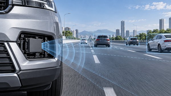
A camera can read lane markings and traffic-light states. LiDAR can produce accurate three-dimensional geometry. Radar can measure relative velocity reliably in conditions that challenge optical sensors. None is complete on its own. A fusion stack exists to turn their different strengths, blind spots, update rates, and error patterns into one usable environmental model for planning and control.
Why Sensor Fusion for Autonomous Vehicles Uses Three Different Sensing Modalities
The familiar shorthand is that cameras provide appearance, LiDAR provides shape, and radar provides motion. That is broadly correct, but it can hide the engineering detail that determines whether a system is dependable.
Cameras offer rich semantic information. They are generally the most practical source for recognizing traffic signs, lane paint, signal colors, vehicle classes, pedestrians, and road context. Their limitations are equally important: low sun, glare, darkness, lens contamination, fog, and poor contrast can weaken detection or classification. A camera also estimates depth indirectly unless it is used in a calibrated stereo or multi-view configuration.
LiDAR directly measures range by timing reflected light. It can define curb edges, vehicle surfaces, free space, and three-dimensional obstacles with a geometry that image-only systems may struggle to infer consistently. Its returns can become sparse or degraded in heavy rain, snow, fog, or on surfaces with weak reflectivity. LiDAR data should therefore be assessed as a point cloud with a measured detection envelope, not simply as a nominal range figure.
Radar is especially valuable because it measures range and radial velocity through radio-frequency reflections. It commonly remains useful in rain, dust, darkness, and some visually difficult scenes. The tradeoff is lower spatial detail and more ambiguous object shape. Radar reflections may come from multiple parts of a vehicle, roadside infrastructure, or nearby objects, so interpreting a radar target requires careful association and tracking.
The practical aim is not to make three sensors “vote.” A good system uses each measurement according to what that measurement can support. A camera may establish that an object is likely a cyclist; LiDAR can tighten its position and size estimate; radar can provide a stable observation of closing speed. The resulting tracked object should carry both an estimated state and a measure of confidence.

Fusion Starts Before Object Detection: Time and Geometry Must Agree
Many integration failures are blamed on perception algorithms when the root cause is synchronization or calibration. If a vehicle travels at speed, even a small delay between sensor timestamps can shift the apparent position of moving objects. That can turn a valid camera detection and a valid radar return into a poor match. The fusion software may then create duplicate tracks, reject a useful measurement, or assign the measurement to the wrong object.
Each sensor stream needs a common time reference or a well-characterized timestamping path. This includes sensor exposure or measurement time, network transport, compute queueing, and the point at which the fusion process consumes the data. “Low latency” is incomplete language unless it specifies where latency is measured and how much timing variation, or jitter, is permitted.
Spatial calibration is just as consequential. Fusion relies on known transformations between every sensor coordinate frame and the vehicle frame. Camera intrinsics describe the lens and image projection. Extrinsics define each sensor’s position and orientation relative to the vehicle. Errors may be small in degrees or millimeters yet become meaningful at distance, particularly when projecting LiDAR points into an image or comparing a radar target with a narrow object boundary.
Calibration cannot be treated as a factory-only task. Vibration, thermal cycling, minor collisions, sensor replacement, bracket tolerance, and body-panel movement can shift the real-world geometry. A production design needs a calibration strategy: controlled end-of-line calibration, diagnostic checks in service, and, where justified, online monitoring that detects drift without silently masking it.
How the Data Is Actually Combined
There is no single fusion architecture that suits every automated driving function. The appropriate level depends on available compute, sensor characteristics, safety goals, and the operational design domain.
Early fusion combines data closer to the raw measurement level. Examples include projecting LiDAR points onto camera images, attaching image features to points, or forming a shared representation from radar and vision data. This can preserve rich information, but it requires very strong synchronization and calibration. It also increases data throughput and makes debugging more demanding.
Feature-level fusion combines intermediate representations produced by separate perception pipelines. A camera network might produce image features, LiDAR might generate clusters or learned point features, and radar might produce target features with velocity information. This approach can capture cross-sensor context without passing all raw data through one large model.
Late fusion combines object lists or tracks. Each subsystem detects objects independently, then a tracker associates observations and updates a shared state estimate. This is often easier to validate because sensor-specific performance remains visible. It can be more tolerant of a single sensor outage, though it may lose information that early fusion could have used to resolve difficult scenes.
In practice, production stacks are often hybrid. A system may use camera-LiDAR feature fusion for object recognition, radar-based track updates for velocity, and a separate free-space or occupancy representation for planning. Architecture labels matter less than traceability: engineers should be able to explain which sensor contributed to a final object state, why a measurement was accepted or rejected, and what happens when the contribution disappears.
Association, Tracking, and Uncertainty Are the Real Safety Work
Detection is only the beginning. The system must decide whether observations from different sensors refer to the same physical object. This is known as data association. It becomes difficult at intersections, in dense traffic, near guardrails, and when several vulnerable road users occupy a small area.
A simple nearest-neighbor match is rarely sufficient. Association should consider position, direction, size, class likelihood, time alignment, expected motion, and sensor-specific uncertainty. A radar target with a measured Doppler velocity can be highly valuable, but it should not be forced onto the nearest camera box merely because the locations overlap in a two-dimensional display.
Tracking estimates an object’s position, velocity, heading, and sometimes acceleration over time. State estimators such as Kalman-filter variants are common because they combine predictions from vehicle motion with noisy measurements. The exact algorithm is less important than its assumptions. A tracker that assumes smooth motion may perform well for vehicles on a highway but need different handling for pedestrians, cyclists, cut-ins, or objects emerging from occlusion.
Confidence should not be interpreted as a vague score. It needs an operational meaning. A useful fusion system represents uncertainty in position, velocity, classification, and existence probability. It also reflects sensor availability. For example, if camera visibility is impaired by glare but radar and LiDAR still support a moving-object track, the system should reduce confidence in appearance-dependent attributes without unnecessarily discarding the object.
Failure Tolerance Is More Important Than Peak Accuracy
A sensor suite can produce impressive results on a clean test route and still be weak in field operation. The harder question is what it does when conditions depart from the nominal case. A blocked camera, a rain-covered LiDAR window, a radar interference event, or an intermittent Ethernet link should not create unexplained behavior in the downstream planner.
Effective fault handling includes sensor health monitoring, plausibility checks, degradation modes, and clear interfaces between perception and planning. Health monitoring may inspect image quality, LiDAR return patterns, radar noise characteristics, temperature, timing, and communication integrity. Plausibility checks compare observations against physical limits and cross-sensor expectations. Neither mechanism should assume that the majority is always correct; two sensors can share a failure mode, particularly in adverse weather or poor installation conditions.
A common mistake is to specify redundancy only by sensor count. Three cameras mounted in similar locations do not provide the same diversity as camera, LiDAR, and radar. Diversity is valuable when failure mechanisms differ. It must still be verified at the vehicle level, because shared power supplies, shared compute hardware, common mounting zones, and common software dependencies can defeat apparent redundancy.
Fallback behavior also needs precision. “Graceful degradation” should be defined in terms of what functions remain enabled, what object classes or ranges are no longer trusted, how the vehicle changes its operating behavior, and how the system reaches a minimal-risk condition when required. A vague promise of continued operation is not a safety argument.
What to Request When Comparing Sensor-Fusion Systems
Marketing materials often present field of view, range, point count, neural-network accuracy, or sensor count in isolation. Those figures can be useful, but they do not establish end-to-end performance. The comparison should move from component specifications to measurable system behavior.
Request scenario definitions, test conditions, and pass criteria alongside aggregate performance claims. A high average detection rate can conceal a weak result in the specific scenario that matters to the intended operational domain. It is also reasonable to ask whether reported results come from simulation, replay data, controlled tracks, public roads, or a mixture. These methods answer different questions and should not be presented as interchangeable.
For systems intended to support safety-related functions, the engineering evidence should connect to the applicable vehicle safety process and local regulatory requirements. Standards and approval pathways differ by market and function, so the relevant official requirements must be checked for the intended deployment rather than inferred from a supplier presentation.
Where Fusion Helps Most, and Where Expectations Should Stay Modest
Sensor fusion is especially helpful in ambiguous scenes: a partially occluded pedestrian near parked vehicles, a motorcycle approaching in low light, a vehicle braking ahead in spray, or cross traffic at an intersection. The sensors provide complementary evidence, allowing the system to maintain a more stable estimate than a single modality would produce.
It does not eliminate fundamental perception limits. Dense fog can reduce optical and LiDAR performance at the same time. A radar return can indicate movement but may not provide enough detail to identify a small hazard reliably. Complex construction zones can challenge object classification, map alignment, and free-space estimation simultaneously. Fusion is an uncertainty-management method, not a guarantee that every scene becomes easy.
This distinction matters when defining requirements. The safer requirement is not “detect all obstacles in all weather.” It is a documented set of operating conditions, object types, ranges, response times, and failure behaviors, followed by evidence that the integrated system meets those conditions with appropriate margin.
FAQ
Can radar replace LiDAR in a fusion system?
Not directly. Radar is strong for range and relative velocity, particularly in difficult weather, but it usually offers less geometric detail. Whether LiDAR is necessary depends on the target function, operational domain, required object resolution, and validated performance evidence.
Is early fusion always more accurate than late fusion?
No. Early fusion can retain more cross-sensor information, but it is more sensitive to calibration and timing errors. Late fusion can be easier to isolate, validate, and degrade safely. The right choice depends on the safety case and system constraints.
How often should sensor calibration be checked?
There is no universal interval. The answer should follow vehicle design, mounting stability, service events, environmental exposure, and diagnostic capability. A credible program defines both initial calibration and conditions that trigger revalidation.
What is the most overlooked fusion requirement?
Timestamp integrity. Teams may verify sensor resolution and detection quality while underestimating transport delays, clock drift, and processing jitter. Those effects can undermine otherwise sound perception outputs.
The most credible approach to sensor fusion for autonomous vehicles is parameter-driven: define the operating domain, quantify timing and calibration error, preserve uncertainty through the perception chain, and prove degraded behavior under realistic faults. That is the level of evidence that separates a compelling sensor demonstration from an autonomous-driving perception system that can be evaluated with confidence.
Search News
Hot Articles
- Carbon Fiber StructuresHow to Specify Aerospace Carbon Fiber Assemblies for Lightweight, Load-Bearing PartsJul 11, 2026
- Machine VisionXiaomi, Alibaba DAMO Academy Drive Open-Source Robotics Model Ecosystem, Lowering Algorithm Development Barriers for Overseas SMEs Adopting Chinese Robotics SolutionsMar 30, 2026
- Cobots & ArmsShanxi 'AI+' Conference Showcases Embodied Intelligence with Multinational Buyer Engagement: Key Industry ImplicationsMar 30, 2026
Popular Tags
Recommended News
 Jul 11, 2026How to Specify Aerospace Carbon Fiber Assemblies for Lightweight, Load-Bearing PartsAerospace carbon fiber assemblies: learn how to specify laminate design, load data, joining methods, and inspection controls for lighter, reliable load-bearing aerospace parts.Elena Rostova (UAV Systems Researcher)
 Mar 30, 2026Xiaomi, Alibaba DAMO Academy Drive Open-Source Robotics Model Ecosystem, Lowering Algorithm Development Barriers for Overseas SMEs Adopting Chinese Robotics SolutionsXiaomi & Alibaba DAMO Academy's open-source robotics models lower algorithm barriers for global SMEs. Boost efficiency in manufacturing, logistics & smart retail with ROS 2 compatible solutions.TSV Data Lab
 Mar 30, 2026Shanxi 'AI+' Conference Showcases Embodied Intelligence with Multinational Buyer Engagement: Key Industry ImplicationsShanxi 'AI+' Conference highlights embodied intelligence with Tesla, Ubtech & Jiantao showcasing multimodal robotics. 40+ global buyers validated tech on-site, creating new B2B channels for industrial automation & AI solutions.Chen Wei (Automation Lead Engineer)
 Mar 30, 2026Zhongguancun Unveils 6G Integrated Sensing-Computing-Intelligence Platform to Empower Embodied Robots for Global Industrial ApplicationsZhongguancun's new 6G platform revolutionizes industrial robotics with <10ms latency, empowering global automotive, logistics & port automation. Discover how this tech boosts China's smart manufacturing exports.TSV Data Lab
 Mar 30, 2026Mech-Mind Tianjin Embodied Intelligence R&D and Production Base Goes Live, Cutting Delivery Time by 20%–30% for Global Customized AMR+Vision SolutionsMech-Mind's Tianjin AMR+Vision production base cuts delivery time by 20%-30% for欧美 & Latin American markets. Discover how this PLd-certified facility accelerates customized robotics solutions for smart manufacturing and logistics.Chen Wei (Automation Lead Engineer)
 Mar 30, 2026Boao Forum Reveals 'Co-evolution of Big and Small Brains' Trend in Humanoid Robots, China's Embodied Intelligence Accelerates Adaptation to Overseas Manufacturing Service ScenariosDiscover how China's humanoid robots, featuring 'Co-evolution of Big and Small Brains,' are revolutionizing global manufacturing. Learn about Embodied Tian Gong 3.0's ISO compliance and overseas deployment at Boao Forum 2026.Chen Wei (Automation Lead Engineer)
 Mar 30, 2026China Railway Industrial Secures Patent for Embodied Robotics in Material Handling, Boosting High-Precision Delivery Capabilities for Overseas Infrastructure and Manufacturing ProjectsChina Railway Industrial's new patent for embodied robotics in material handling boosts high-precision delivery for global infrastructure & manufacturing. Discover how this innovation enhances logistics accuracy in automotive, rail transit & EPC projects.Chen Wei (Automation Lead Engineer)
 Oct 14, 2026Drone Frame Composites: Carbon Fiber vs. Fiberglass for Weight and StiffnessExplore drone structural materials composites: compare carbon fiber and fiberglass for weight, stiffness, cost, and antenna compatibility. Find the right material for your drone frame.Elena Rostova (UAV Systems Researcher)
 Oct 13, 2026Smart Cameras vs. PC-Based Machine Vision: Which Fits High-Speed Inspection?This industrial product comparison for machine vision weighs smart cameras vs. PC-based systems on latency, throughput, and cost. Discover your best fit for high-speed inspection.TSV Data Lab
 Oct 12, 2026How to Verify RoHS Compliance in Industrial Sensing Systems Before DeploymentRoHS compliant sensing systems: learn how to verify materials, supplier declarations, testing, and configuration controls before industrial deployment.TSV Data Lab
 Oct 11, 2026How Procurement-Oriented Content Taxonomy Improves B2B Buying JourneysProcurement-oriented content taxonomy streamlines B2B buying journeys with clearer evidence, supplier comparisons, risk visibility, and faster approvals.TSV Data Lab
 Oct 10, 2026How to Select a Machine Performance Monitoring Platform for OEE and Downtime ReductionMachine performance monitoring platform selection guide: validate machine states, OEE data, downtime reasons, integrations, and scalability to reduce losses with confidence.TSV Data Lab
 Oct 08, 2026How to Machine Inconel 625 Blades Without Heat Cracks or Edge ChippingInconel 625 blade machining guide: prevent heat cracks, edge chipping, chatter, and work hardening with proven tooling, cooling, fixturing, and inspection strategies.Dr. Marcus Vance
 Oct 07, 2026How to Evaluate an HMI Panel Distributor for Industrial Automation ProjectsHMI panel distributor evaluation guide: verify technical compatibility, traceability, supply reliability, lifecycle support, and total cost for automation projects.Victor Lin (Chief Software Architect)
 Oct 06, 2026Navigation Fault Tolerance Standards for AMRs: What Safety Teams Must VerifyNavigation fault tolerance standards: learn what AMR safety teams must verify, from localization loss and sensor faults to stopping distance, safe restart, and site-specific validation.Chen Wei (Automation Lead Engineer)
 Oct 05, 2026Calculating Edge Computing Total Cost of Ownership Across Distributed SitesEdge computing ownership cost explained: calculate deployment, energy, connectivity, security, remote support, and refresh costs across distributed sites.TSV Data Lab
 Oct 04, 2026CAD/CAM Benchmarking in the GCC: What Manufacturers Should Ask a ConsultantCAD CAM benchmark consultant GCC guide: learn the key questions manufacturers should ask to validate post-processors, workflows, machine performance, and production risk.Victor Lin (Chief Software Architect)
 Oct 03, 2026Selecting Automotive Radar Sensor Modules for ADAS Range, Resolution, and IntegrationAutomotive radar sensor module selection guide for ADAS: compare range, resolution, field of view, latency, and integration to build safer, reliable vehicle systems.TSV Data Lab
 Oct 02, 2026How to Qualify Machined Parts Suppliers for Hard Tech ProgramsHard tech supply chain machined parts demand rigorous supplier qualification. Learn how to assess capability, traceability, quality controls, and delivery resilience.Dr. Marcus Vance
 Oct 01, 2026How to Select an Outdoor Security Radar Sensor for Perimeter Detection?Outdoor security radar sensor selection guide: compare range, accuracy, false-alarm control, integration, and field testing for reliable perimeter detection.TSV Data Lab
 Sep 30, 2026How to Evaluate Solid-State LiDAR Hardware for Outdoor Autonomous VehiclesSolid state LiDAR hardware evaluation guide for outdoor autonomous vehicles—compare range, point-cloud quality, environmental resilience, integration, and safety.TSV Data Lab
 Sep 29, 2026ISO 9283 Repeatability: How to Evaluate Cobot Positioning PerformanceISO 9283 cobot repeatability explained: learn how payload, reach, approach direction, and test conditions affect positioning performance and cell capability.Chen Wei (Automation Lead Engineer)
 Oct 14, 2026How tight can micro machining aerospace tolerances be in production?Micro machining aerospace tolerances can reach low-micron levels in production. Learn what controls repeatability, inspection confidence, and flight-critical quality.Dr. Marcus Vance
 Oct 13, 2026How to keep an industrial robotic integration project on scheduleIndustrial robotic integration project management: keep automation on schedule with proven controls for interfaces, suppliers, FAT, commissioning, and change risk.Victor Lin (Chief Software Architect)