Can a radar sensor for traffic monitoring handle dense urban traffic?
Publication Date
author
Can a radar sensor for traffic monitoring reliably interpret dense urban traffic where occlusion, multipath interference, and nonstop motion challenge detection accuracy? For engineers, buyers, and smart city planners, the answer depends on measurable performance—range resolution, radar false positive rate analysis, and how well it integrates with edge computing for smart city systems and sensor fusion lidar and camera architectures.
In practice, dense urban traffic is one of the hardest environments for roadside sensing. Vehicles overlap across 4–8 lanes, buses hide motorcycles, glass and steel create reflections, and intersections can generate hundreds of moving targets per minute. A radar sensor for traffic monitoring can handle this complexity, but only when the system is specified, deployed, and validated against engineering metrics rather than marketing claims.
For research teams, operators, procurement managers, and enterprise decision-makers, the key question is not whether radar works in theory. The real question is how well a given sensor maintains detection stability in rain, low light, congestion, and mixed-speed traffic while keeping false alarms, missed detections, and integration costs under control. That is the basis for a data-driven evaluation.
Why dense urban traffic is a difficult test for roadside radar
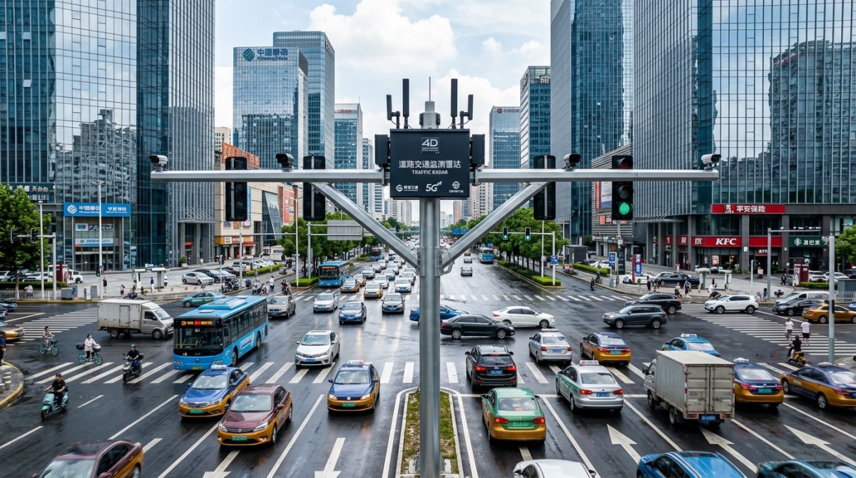
A radar sensor for traffic monitoring performs well when it can separate multiple targets in limited space and maintain reliable tracking over time. Urban intersections, tunnels, arterial roads, and curbside zones compress many objects into a short field of view. In a 50–120 meter coverage zone, the sensor may need to distinguish cars, trucks, bicycles, e-scooters, and pedestrians moving at very different speeds.
The first challenge is occlusion. A large delivery van can block 2–3 smaller vehicles, while a stopped bus may hide an entire crosswalk approach. Unlike a single camera, radar can still detect motion and distance through partial obstruction, but performance depends on angular resolution, vertical beam design, and tracking software. If these are weak, the system may merge separate objects into one track or lose targets during lane changes.
The second challenge is multipath interference. Urban materials such as metal barriers, wet pavement, concrete walls, and glass façades reflect radar energy. These reflections can create ghost targets or incorrect position estimates, especially near underpasses and enclosed corridors. In procurement terms, this is where radar false positive rate analysis becomes essential. A system that detects “everything” but produces unstable tracks can overwhelm operators and reduce trust in the data.
The third challenge is nonstop motion. At a busy signalized junction, a roadside unit may observe 30–80 concurrent targets during peak periods. Short dwell times, abrupt acceleration, stop-and-go behavior, and turning traffic force the sensor to refresh and reclassify constantly. Systems with slow processing pipelines or weak target association logic will show track fragmentation, duplicate counting, or delayed event outputs.
Core technical stressors in urban deployment
- High target density across 3–8 lanes with mixed vehicle sizes and vulnerable road users.
- Frequent line-of-sight obstruction caused by buses, trucks, roadside trees, and signal poles.
- Strong reflections from wet roads, steel structures, and building façades within 20–60 meters.
- Rapid velocity changes from 0 km/h to 50 km/h in short intervals at intersections and merge zones.
For this reason, “urban capable” should never be accepted as a vague product promise. Buyers should ask for target density assumptions, tested mounting heights, angular coverage, and evidence of stable detection under congestion. A radar sensor for traffic monitoring is only as useful as its measured performance in the exact geometry where it will be installed.
Which performance metrics actually determine whether radar can handle congestion
The most important selection mistake is focusing only on advertised range. In dense city traffic, long-distance reach matters less than the quality of separation, classification, and tracking inside the practical operating zone. Many deployments only require 60–150 meters of effective coverage, but they require precise target discrimination within that space. That makes resolution and algorithm quality more important than a headline maximum distance.
Range resolution affects how closely spaced objects can be distinguished. If two motorcycles are only 0.7–1.2 meters apart, poor resolution can combine them into one detection. Angular resolution matters just as much. In urban lane groups, a sensor needs enough azimuth detail to distinguish adjacent vehicles, turning paths, and curbside activity. Update rate is another practical metric; a traffic scene with abrupt starts and lane changes benefits from fast refresh cycles and low-latency output to downstream systems.
Operators should also examine false positive and false negative behavior separately. A low miss rate with excessive ghost detections is not operationally efficient. Conversely, a conservative filter that suppresses uncertain targets may reduce noise but miss cyclists or partially occluded pedestrians. Procurement teams should request confusion patterns by use case: free-flow traffic, queue discharge, rain, night, and mixed vehicle-pedestrian movement.
For edge deployments, latency matters beyond pure sensing. If radar data is sent to an edge box for fusion or event generation, end-to-end delay often needs to stay within roughly 100–300 milliseconds for adaptive signal control, incident warning, or wrong-way alerts. A technically strong sensor can still underperform if the data pipeline, packet handling, or protocol integration is unstable.
Practical metric checklist for engineering and procurement teams
The table below summarizes the metrics that deserve more attention than simple range claims when evaluating a radar sensor for traffic monitoring in dense urban conditions.
The key takeaway is simple: the best radar sensor for traffic monitoring is not the one with the longest datasheet range, but the one that maintains high-quality target separation and stable outputs in your actual urban geometry. That is especially important when the system must feed adaptive signals, enforcement analytics, or digital twin platforms.
Signals that a specification is incomplete
- It gives maximum range but no tested detection quality at 4-way intersections.
- It mentions AI classification but provides no confusion behavior for bikes, scooters, and pedestrians.
- It claims congestion support without describing track stability under 30+ simultaneous targets.
- It provides no radar false positive rate analysis for wet roads, tunnels, or reflective façades.
How radar compares with camera-only and fused sensing in smart city systems
A radar sensor for traffic monitoring is rarely evaluated in isolation today. Smart city deployments increasingly compare three architectures: radar-only, camera-only, and sensor fusion lidar and camera or radar-camera fusion. Each has a different balance of resilience, privacy profile, compute demand, and maintenance burden. The correct choice depends on whether the city needs counting, speed estimation, incident detection, near-miss analysis, or multimodal classification.
Radar’s strongest advantage is environmental robustness. It performs well in darkness, glare, fog, and moderate rain where image-only systems can degrade. It also directly measures velocity and distance, which is valuable for traffic flow analytics and speeding scenarios. However, radar classification granularity can be weaker than vision in some curbside or pedestrian-rich environments unless the signal processing stack is mature.
Camera-only systems provide rich semantic detail, but they are more sensitive to shadows, low-light conditions, and occlusion. In dense urban canyons, a single camera may struggle when buses block smaller targets for several seconds. That is why many advanced projects use edge computing for smart city systems to fuse radar with video or lidar. The fusion layer can combine radar’s velocity confidence with the object class and visual context provided by other sensors.
From a procurement standpoint, fusion is not automatically the best answer. It can increase hardware count, calibration work, bandwidth, and software complexity. A city with 200 intersections may find that a well-chosen radar sensor for traffic monitoring solves 70–80% of its operational goals at lower lifecycle complexity, while a smaller number of high-risk sites justify full multimodal fusion.
Architecture comparison for urban monitoring
The comparison below helps decision-makers align sensing architecture with actual deployment goals rather than abstract technology preference.
The practical conclusion is that radar is highly viable in dense urban traffic, especially for speed, presence, queue, and trajectory monitoring. Fusion becomes more attractive when the project requires detailed object semantics, post-event visual evidence, or safety analytics across multimodal road users in very complex zones.
Deployment, integration, and edge processing factors that shape real-world results
Even a technically capable radar sensor for traffic monitoring can underperform when deployment details are neglected. Mounting height, tilt angle, lateral offset, and roadside clutter all affect detection quality. Typical urban installations may use elevated poles at roughly 5–10 meters, but the correct setup depends on whether the system is monitoring stop bars, through lanes, crosswalk approaches, or long arterial segments.
Edge computing for smart city systems plays a major role in making radar data usable. Raw detections are often not enough for operations teams. The edge layer may need to perform target filtering, zone mapping, event classification, data compression, and protocol translation before sending outputs to VMS, traffic signal controllers, or analytics dashboards. If the edge node is undersized, data may arrive late or inconsistently during peak traffic loads.
Integration planning should also include communications and maintenance. A system covering 20 intersections might tolerate modest bandwidth if it transmits events only. A network of 200 sites may require more disciplined architecture, including local processing, secure firmware management, and diagnostic monitoring. Procurement teams should ask whether remote health checks, software updates, and calibration verification can be done without repeated field visits, because truck rolls quickly increase lifecycle cost.
Validation should happen in phases. A sound process includes site survey, pilot setup, scenario testing, parameter tuning, and acceptance. In dense urban traffic, at least 3 categories of test scenes are advisable: normal daytime flow, peak congestion, and adverse visibility such as rain or nighttime glare. This is more useful than a single “successful demo” because it reveals how stable the radar remains across operating states.
Recommended rollout workflow
- Step 1: Survey lane geometry, pole locations, reflective surfaces, and likely occlusion points within 50–150 meters.
- Step 2: Define measurable acceptance criteria such as queue detection stability, target separation, and alert latency.
- Step 3: Run a pilot for 2–4 weeks across weekday peak and off-peak conditions.
- Step 4: Tune zones, filters, and edge rules using field data rather than default settings.
- Step 5: Expand deployment only after verifying maintainability, remote diagnostics, and integration reliability.
For enterprise buyers, this phase is where suppliers become distinguishable. The stronger vendors are usually the ones that can discuss not only the sensor itself, but also calibration workload, integration protocol support, maintenance intervals, and operational data quality. In a hard-tech environment, deployment discipline is often as important as the sensing hardware.
Procurement questions, common pitfalls, and a practical buying framework
When selecting a radar sensor for traffic monitoring, procurement teams should move beyond brochure language and ask for scenario-based evidence. Dense urban traffic requires proof that the system can manage occlusion, track stability, and reflective interference without creating excessive maintenance work. A low upfront price can become expensive if the system needs repeated tuning, frequent site visits, or supplementary sensors to correct avoidable blind spots.
One common mistake is evaluating only average accuracy. Urban traffic systems fail operationally at the edge cases: left-turn pockets full of motorcycles, bus stop bypasses, rain-polished streets, or complex T-junctions with mixed pedestrians and vehicles. Buyers should request testing by scenario and ask how performance shifts under target density, weather, and mounting constraints. Another mistake is ignoring integration maturity. If outputs are difficult to map into existing controllers or city platforms, deployment timelines can slip by 4–8 weeks.
A practical buying framework should include technical fit, deployment complexity, data usability, and serviceability. For many city and industrial mobility projects, those four dimensions are more predictive of long-term value than isolated detection claims. This approach aligns with TSV’s engineering-first view: parameters, tolerances, and validation workflows matter more than broad performance adjectives.
Vendor evaluation matrix
The following matrix can help research teams and buyers structure a supplier comparison before pilot approval.
The strongest procurement outcome usually comes from a limited pilot with explicit pass criteria. Instead of asking whether the system is “advanced,” ask whether it can sustain lane-level tracking, acceptable alert latency, and manageable false detections over a 2–4 week test cycle in dense traffic. Those answers are more actionable for both engineering and business decisions.
Frequently asked technical buying questions
How many sensors are typically needed for one urban intersection?
It depends on lane count, pole placement, and whether the city needs full approach coverage or only selected movements. A compact 4-leg junction may be handled with 1–2 well-positioned units, while larger intersections with heavy turning traffic and curbside activity may require 3–4 sensing points for reliable coverage and reduced occlusion risk.
Is radar enough without cameras?
For speed, presence, queue estimation, occupancy, and many traffic actuation tasks, yes, radar can be sufficient. If the application requires visual evidence, detailed object appearance, or nuanced pedestrian behavior analysis, fusion with camera or sensor fusion lidar and camera architectures may be more appropriate at selected sites.
What deployment period should buyers expect before acceptance?
For a disciplined project, site survey and preparation may take 1–2 weeks, pilot validation 2–4 weeks, and integration plus tuning another 1–3 weeks depending on platform complexity. Larger city rollouts take longer, but even then, phased acceptance is preferable to a single bulk installation.
A radar sensor for traffic monitoring can handle dense urban traffic, but only when buyers evaluate it through measurable engineering performance: target separation, latency, false positive control, integration maturity, and maintainability under real city conditions. For teams building data-driven traffic systems, the best results come from scenario-based validation, not generic product language.
At TechStat Vanguard, we approach this category the way advanced manufacturing and infrastructure teams should approach every hard-tech decision: by reducing noise and focusing on parameters that change project outcomes. If you are comparing urban radar solutions, planning a pilot, or reviewing fusion architectures for smart city deployment, contact us to discuss a more technical evaluation framework, request a tailored assessment checklist, or explore solution paths aligned with your deployment goals.
Search News
Hot Articles
- Carbon Fiber StructuresHow to Specify Aerospace Carbon Fiber Assemblies for Lightweight, Load-Bearing PartsJul 11, 2026
- Machine VisionXiaomi, Alibaba DAMO Academy Drive Open-Source Robotics Model Ecosystem, Lowering Algorithm Development Barriers for Overseas SMEs Adopting Chinese Robotics SolutionsMar 30, 2026
- Cobots & ArmsShanxi 'AI+' Conference Showcases Embodied Intelligence with Multinational Buyer Engagement: Key Industry ImplicationsMar 30, 2026
Popular Tags
Recommended News
 Jul 11, 2026How to Specify Aerospace Carbon Fiber Assemblies for Lightweight, Load-Bearing PartsAerospace carbon fiber assemblies: learn how to specify laminate design, load data, joining methods, and inspection controls for lighter, reliable load-bearing aerospace parts.Elena Rostova (UAV Systems Researcher)
 Mar 30, 2026Xiaomi, Alibaba DAMO Academy Drive Open-Source Robotics Model Ecosystem, Lowering Algorithm Development Barriers for Overseas SMEs Adopting Chinese Robotics SolutionsXiaomi & Alibaba DAMO Academy's open-source robotics models lower algorithm barriers for global SMEs. Boost efficiency in manufacturing, logistics & smart retail with ROS 2 compatible solutions.TSV Data Lab
 Mar 30, 2026Shanxi 'AI+' Conference Showcases Embodied Intelligence with Multinational Buyer Engagement: Key Industry ImplicationsShanxi 'AI+' Conference highlights embodied intelligence with Tesla, Ubtech & Jiantao showcasing multimodal robotics. 40+ global buyers validated tech on-site, creating new B2B channels for industrial automation & AI solutions.Chen Wei (Automation Lead Engineer)
 Mar 30, 2026Zhongguancun Unveils 6G Integrated Sensing-Computing-Intelligence Platform to Empower Embodied Robots for Global Industrial ApplicationsZhongguancun's new 6G platform revolutionizes industrial robotics with <10ms latency, empowering global automotive, logistics & port automation. Discover how this tech boosts China's smart manufacturing exports.TSV Data Lab
 Mar 30, 2026Mech-Mind Tianjin Embodied Intelligence R&D and Production Base Goes Live, Cutting Delivery Time by 20%–30% for Global Customized AMR+Vision SolutionsMech-Mind's Tianjin AMR+Vision production base cuts delivery time by 20%-30% for欧美 & Latin American markets. Discover how this PLd-certified facility accelerates customized robotics solutions for smart manufacturing and logistics.Chen Wei (Automation Lead Engineer)
 Mar 30, 2026Boao Forum Reveals 'Co-evolution of Big and Small Brains' Trend in Humanoid Robots, China's Embodied Intelligence Accelerates Adaptation to Overseas Manufacturing Service ScenariosDiscover how China's humanoid robots, featuring 'Co-evolution of Big and Small Brains,' are revolutionizing global manufacturing. Learn about Embodied Tian Gong 3.0's ISO compliance and overseas deployment at Boao Forum 2026.Chen Wei (Automation Lead Engineer)
 Mar 30, 2026China Railway Industrial Secures Patent for Embodied Robotics in Material Handling, Boosting High-Precision Delivery Capabilities for Overseas Infrastructure and Manufacturing ProjectsChina Railway Industrial's new patent for embodied robotics in material handling boosts high-precision delivery for global infrastructure & manufacturing. Discover how this innovation enhances logistics accuracy in automotive, rail transit & EPC projects.Chen Wei (Automation Lead Engineer)
 Oct 27, 2026GXO and Agility Robotics Expand Partnership to Accelerate US Humanoid Robot DeploymentGXO and Agility Robotics plan to expand US humanoid robot deployment with Digit 4 in early 2027. Explore warehouse automation plans, service terms and future Digit 5 upgrades.Chen Wei (Automation Lead Engineer)
 Oct 27, 2026Robotic Automation Costs: Budgeting for Equipment, Integration, and MaintenancePlan your robotics automation cost with confidence. Explore equipment, integration, and maintenance expenses, compare quotes, and build a realistic budget for better ROI.Chen Wei (Automation Lead Engineer)
 Oct 26, 2026AMAXiMAL Releases Open-Source TopMod 3D v3 With Claude AIExplore AMAXiMAL’s free, open-source TopMod 3D v3 with Claude AI assistance, topology-based modeling and plywood fabrication tools that connect complex designs to physical builds.Dr. Marcus Vance
 Oct 26, 2026Choosing a SCADA System Integrator Company: PLC Compatibility and Long-Term SupportChoose a scada system integrator company with proven PLC compatibility and reliable long-term support. Discover what to test, compare, and require before investing.Victor Lin (Chief Software Architect)
 Oct 25, 2026Hesai Leads Global ADAS Main Lidar Shipments in Yole’s 2026 ReportHesai led global ADAS main lidar shipments with a 43% share in 2025, according to Yole’s 2026 report. Explore what this ranking reveals about its automotive market position.TSV Data Lab
 Oct 25, 2026Choosing an Aerospace Materials Manufacturer: Quality and Traceability ChecksChoosing an aerospace materials manufacturer? Learn how to verify certifications, test reports, and lot traceability to qualify suppliers confidently and reduce costly sourcing risks.Dr. Marcus Vance
 Oct 24, 2026Guotai Haitong: Global Entry-Level 3D Printer Shipments Rose 39% in Q1 2026Entry-level 3D printer shipments rose 39% in Q1 2026, Guotai Haitong reports. Explore how AI, multicolor printing and print farms are shaping market growth.Dr. Marcus Vance
 Oct 24, 2026Choosing an Industrial Vision Inspection Supplier: Acceptance Tests That MatterChoose an industrial vision inspection supplier with confidence. Discover acceptance tests for defect detection, false rejects, production speed, and reliable part rejection before you buy.TSV Data Lab
 Oct 23, 2026US Navy Raises Gecko Robotics Contract Ceiling to $300M for Robotic Fleet MaintenanceUS Navy raises Gecko Robotics’ contract ceiling to $300M for Pacific Fleet robotic inspections. Explore potential opportunities for maintenance suppliers and key procurement considerations.Chen Wei (Automation Lead Engineer)
 Oct 23, 2026Choosing Industrial Sensing Systems for Global Plants: Protocol CompatibilityCompare industrial sensing systems international buyers can trust. Explore protocol compatibility, reduce integration risks, and select proven configurations for reliable global plant deployments.TSV Data Lab
 Oct 22, 2026KUKA Showcases Physical AI and iiQKA.AI Vision at NVIDIA GTC BerlinExplore KUKA’s Physical AI showcase at NVIDIA GTC Berlin and discover how iiQKA.AI Vision aims to simplify robotic vision integration and improve 2D and 3D scene recognition.TSV Data Lab
 Oct 22, 2026Robotic Machining of Advanced Composites: What Tolerances Are Achievable?Explore advanced materials machining robotics: discover what drives achievable composite tolerances and how to validate accuracy before investing in your next machining system.Dr. Marcus Vance
 Oct 21, 2026China’s Industrial Robot Exports Near RMB 10 Billion in First Nine Months of 2026China’s industrial robot exports neared RMB 10 billion in January–September 2026, with value rising faster than volume. Explore the data and what it could mean for suppliers.Chen Wei (Automation Lead Engineer)
 Oct 21, 2026Low-Latency Industrial Data Processing: Pricing and Key Cost DriversExplore industrial data latency price drivers, from edge hardware to integration and support. Learn how to compare quotes, verify performance, and avoid unnecessary costs.TSV Data Lab
 Oct 20, 2026KUKA Launches iiQKA.AI Vision to Simplify Industrial Image ProcessingKUKA iiQKA.AI Vision simplifies industrial image processing with controller-based 2D and 3D vision. Explore drag-and-drop setup for vision-guided automation.TSV Data Lab
 Oct 20, 2026Smart Industrial Edge Devices: Key Criteria for Legacy PLC IntegrationChoose smart industrial edge devices for legacy PLC integration. Discover key criteria for compatibility, data quality, security, and reliable collection without disrupting control.TSV Data Lab
 Oct 19, 2026Choosing a Radar Sensor by Application: Range, Resolution, and Field of ViewSimplify radar sensor application based product selection. Compare range, resolution, and field of view to avoid blind spots and choose with confidence. Explore the guide.TSV Data Lab