UAV LiDAR for topographical survey versus ground methods
Publication Date
author
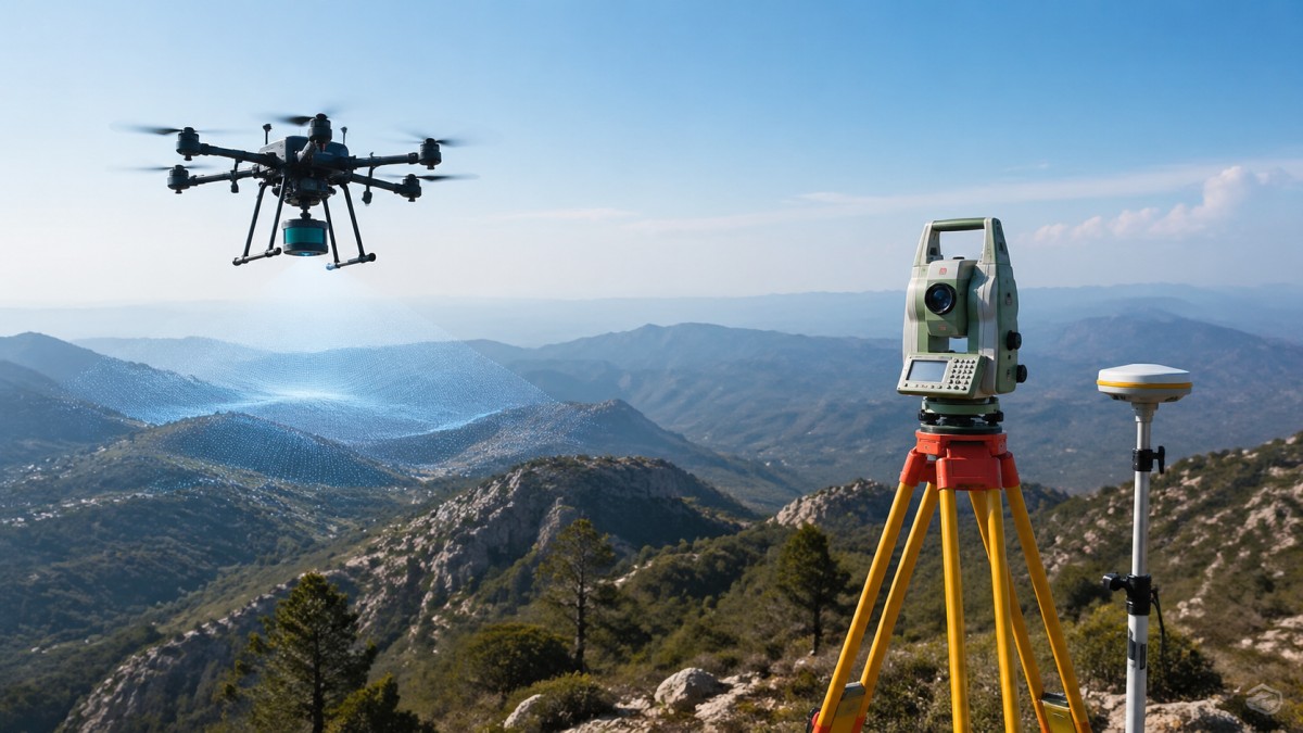
Choosing between UAV LiDAR for topographical survey and ground-based methods is no longer just a technical preference. It directly affects how fast a team can capture terrain, how safely it can work in difficult areas, how much post-processing will be required, and whether the final dataset is fit for design, earthwork estimation, drainage planning, corridor mapping, or asset development. The short answer is this: UAV LiDAR is usually the stronger option when speed, terrain access, vegetation penetration, and large-area efficiency matter most, while ground methods still remain essential when a project requires localized control, very high detail in small areas, or verification-grade measurements in constrained environments. For procurement teams and technical decision-makers, the real question is not which method is universally better, but which workflow produces the required accuracy, density, and project economics with the lowest operational risk.
What decision-makers really need to know before choosing UAV LiDAR or ground survey
Most readers searching for “UAV LiDAR for topographical survey versus ground methods” are not looking for a basic definition. They want to know which method is more accurate in practice, what the total cost looks like, whether UAV data can be trusted for engineering use, and where each option fails.
For most topographic projects, the most useful way to compare the two is across six decision factors:
- Required accuracy and tolerance
- Site size and terrain accessibility
- Vegetation and surface visibility
- Turnaround time
- Field safety and labor intensity
- Total project cost, including rework risk
Ground methods are still the benchmark for point-specific, highly controlled measurements. Total stations, GNSS rovers, and terrestrial laser scanners can deliver excellent precision, especially on small sites or where line-of-sight can be managed. But when a site is large, steep, muddy, forested, fragmented, or time-sensitive, UAV LiDAR often shifts the economics and practicality of survey work in a major way.
Where UAV LiDAR clearly outperforms ground methods
UAV LiDAR becomes especially valuable when topographical survey work is slowed down by terrain, scale, or surface complexity.
1. Large-area coverage in less time
A drone can cover far more ground in a single mission than a walking survey crew can typically measure in the same time window. For linear infrastructure, mining zones, construction staging areas, floodplains, quarries, and semi-rural development parcels, this speed advantage is often the first reason teams adopt aerial workflows.
2. Better access to dangerous or inefficient terrain
Steep slopes, unstable soil, wetlands, scrubland, roadside embankments, and post-rain surfaces can all make conventional ground methods slower and riskier. UAV LiDAR reduces direct human exposure in these environments while still generating usable terrain data.
3. Better performance in vegetated terrain
One of the strongest advantages of LiDAR over many purely image-based workflows is its ability to capture returns through gaps in vegetation. In topographical survey applications where bare-earth modeling matters, this is often decisive. Photogrammetry can struggle where canopy, brush, or variable texture reduce reliable surface reconstruction. UAV LiDAR is not magic, but it is usually much more effective for extracting ground surface in partially covered environments.
4. Higher operational efficiency for repeat surveys
If a project needs periodic progress mapping, stockpile tracking, corridor monitoring, or site change detection, UAV LiDAR can be integrated into repeatable workflows. This matters to organizations already considering a UAV fleet management system for multi-site operations, because standardized flight planning, sensor payloads, and processing pipelines can reduce long-term survey friction.
5. Stronger integration with digital engineering workflows
Modern UAV survey programs are no longer just about flying and exporting points. They depend on processing, classification, control alignment, and deliverable generation. This is where drone photogrammetry software and LiDAR processing environments increasingly intersect. Many teams now combine LiDAR for terrain reliability with imagery for orthomosaics, texture, and visual context.
Where ground survey methods still win
Despite the growth of UAV LiDAR, ground methods are still critical and in many projects non-negotiable.
1. Highest confidence in local control and check data
Ground control and independent checkpoints remain essential for validating survey outputs. Even when UAV LiDAR is the primary collection method, ground survey often serves as the quality backbone.
2. Small sites with dense detail requirements
If the survey area is compact and the project requires highly specific feature capture, localized breaklines, utility references, edge conditions, or structural tie-ins, ground crews may complete the work more directly with less data filtering.
3. Areas with restricted airspace or flight limitations
Urban zones, sensitive industrial facilities, airports, defense-adjacent locations, and heavily regulated environments may limit or complicate drone operations. In those cases, ground methods can be simpler from a compliance standpoint.
4. Interior, under-structure, or obstructed environments
UAV LiDAR is not the best choice everywhere. Under bridges, inside facilities, beneath heavy overhangs, or in environments with severe GNSS degradation, terrestrial methods are often more dependable.
5. Precision-critical stakeout and direct engineering verification
Topographic mapping is one task; construction layout and legal boundary verification are another. Ground instruments remain the standard for many direct measurement and setting-out activities where tolerance accountability is tightly controlled.
Accuracy: the most misunderstood part of the comparison
Accuracy is often discussed too generally. The right question is not whether UAV LiDAR is “accurate” and ground survey is “more accurate.” The real issue is: accurate enough for what deliverable, under what site conditions, with what control design, and after what processing workflow?
Ground methods usually provide stronger point-level confidence when measurements are taken carefully and directly. However, UAV LiDAR can produce highly reliable topographic outputs when mission planning, sensor calibration, GNSS/IMU quality, control strategy, and classification workflow are well managed.
In practice, project outcomes are influenced by:
- Sensor grade and calibration stability
- Flight altitude and speed
- Point cloud density
- Ground control and checkpoint layout
- Vegetation density and surface reflectivity
- Operator skill in classification and terrain extraction
This is why buyers should avoid vendor language that only promotes headline specs. A LiDAR payload’s advertised performance does not automatically equal final topographical survey quality. Engineering teams should ask for demonstrated accuracy reports, sample deliverables, checkpoint methodology, and terrain classification examples from similar environments.
This is also relevant when evaluating sourcing options, including a solid state lidar manufacturer China may offer for UAV integration. Hardware selection should never be based only on price or raw point rate. Teams should evaluate waveform behavior, return reliability, calibration support, software compatibility, thermal stability, and field-proven consistency.
Cost comparison: field savings do not always equal total savings
One of the biggest mistakes in procurement is comparing only visible fieldwork cost. UAV LiDAR may reduce time on site, but total project economics depend on a broader chain:
- Mobilization and staffing
- Flight permissions and compliance
- Sensor and platform cost
- Control survey effort
- Processing software and computing time
- Classification labor
- QA/QC and deliverable formatting
- Risk of resurvey due to bad coverage or missed features
For large or difficult sites, UAV LiDAR often reduces total cost because the gain in speed, access, and coverage outweighs processing overhead. For very small sites, however, the setup, flight planning, and data handling may not produce a meaningful economic advantage over conventional ground methods.
Decision-makers should compare methods using a project-level model, not a day-rate model. Ask:
- How many hectares or corridor kilometers must be captured?
- How much of the site is difficult or unsafe to traverse?
- How often will the area be revisited?
- What level of terrain filtering and CAD-ready output is required?
- What is the cost of schedule delay if data collection is slow?
In many organizations, the answer is not “replace ground survey,” but “use UAV LiDAR to reduce labor-heavy capture, then use ground teams for control and exceptions.” That hybrid model is often the most financially rational.
When a hybrid workflow is the best engineering choice
For serious topographical survey programs, the best answer is often not either-or. It is a combined workflow that uses each method where it performs best.
A common high-value workflow looks like this:
- Use ground survey to establish control and checkpoints.
- Deploy UAV LiDAR for rapid site-wide terrain capture.
- Use imagery to support visual interpretation and feature context.
- Process the point cloud using established classification standards.
- Perform ground verification in ambiguous or tolerance-critical areas.
This approach is especially useful in infrastructure, industrial development, mining, utility corridors, and large construction environments. It also aligns well with enterprise digitization goals, where repeat survey operations, software standardization, and centralized QA/QC become part of a scalable geospatial program.
How buyers and operators should evaluate a UAV LiDAR solution
If your organization is considering investment rather than outsourcing, focus on system performance in real operational conditions.
For operators and technical teams, evaluate:
- Ease of mission planning and calibration workflow
- GNSS/IMU robustness
- Point cloud classification workflow
- Compatibility with existing CAD, GIS, and survey deliverables
- Training burden and field repeatability
For procurement teams, evaluate:
- Total cost of ownership, not just hardware price
- Maintenance, support, firmware maturity, and spare part access
- Sensor data quality documentation
- Interoperability with drone photogrammetry software and LiDAR toolchains
- Vendor track record in your application type
For enterprise decision-makers, evaluate:
- Whether survey demand is frequent enough to justify internal capability
- Whether a UAV fleet management system is needed for scale
- How standardized workflows will reduce rework and qualification delays
- How the data will support engineering, asset management, and planning decisions beyond survey alone
The strongest ROI usually comes when UAV LiDAR is treated as part of an integrated measurement and data operations strategy, not as a standalone gadget purchase.
Final judgment: which method should you choose?
If your project involves large areas, uneven ground, vegetation, access limitations, or recurring survey demand, UAV LiDAR for topographical survey is often the more efficient and operationally valuable choice. If your work is highly localized, airspace-constrained, structurally obstructed, or tolerance-critical at specific points, ground methods remain indispensable. For many professional teams, the best answer is a hybrid workflow that combines UAV speed and terrain coverage with ground-based control and verification.
The key takeaway is simple: do not compare methods by hype, and do not compare them by hardware brochure alone. Compare them by deliverable requirements, site conditions, workflow maturity, and total project risk. When judged on those terms, UAV LiDAR is not a universal replacement for ground survey—but in the right conditions, it is a major upgrade in topographical survey capability, speed, and decision value.
Search News
Hot Articles
- Carbon Fiber StructuresHow to Specify Aerospace Carbon Fiber Assemblies for Lightweight, Load-Bearing PartsJul 11, 2026
- Machine VisionXiaomi, Alibaba DAMO Academy Drive Open-Source Robotics Model Ecosystem, Lowering Algorithm Development Barriers for Overseas SMEs Adopting Chinese Robotics SolutionsMar 30, 2026
- Cobots & ArmsShanxi 'AI+' Conference Showcases Embodied Intelligence with Multinational Buyer Engagement: Key Industry ImplicationsMar 30, 2026
Popular Tags
Recommended News
 Jul 11, 2026How to Specify Aerospace Carbon Fiber Assemblies for Lightweight, Load-Bearing PartsAerospace carbon fiber assemblies: learn how to specify laminate design, load data, joining methods, and inspection controls for lighter, reliable load-bearing aerospace parts.Elena Rostova (UAV Systems Researcher)
 Mar 30, 2026Xiaomi, Alibaba DAMO Academy Drive Open-Source Robotics Model Ecosystem, Lowering Algorithm Development Barriers for Overseas SMEs Adopting Chinese Robotics SolutionsXiaomi & Alibaba DAMO Academy's open-source robotics models lower algorithm barriers for global SMEs. Boost efficiency in manufacturing, logistics & smart retail with ROS 2 compatible solutions.TSV Data Lab
 Mar 30, 2026Shanxi 'AI+' Conference Showcases Embodied Intelligence with Multinational Buyer Engagement: Key Industry ImplicationsShanxi 'AI+' Conference highlights embodied intelligence with Tesla, Ubtech & Jiantao showcasing multimodal robotics. 40+ global buyers validated tech on-site, creating new B2B channels for industrial automation & AI solutions.Chen Wei (Automation Lead Engineer)
 Mar 30, 2026Zhongguancun Unveils 6G Integrated Sensing-Computing-Intelligence Platform to Empower Embodied Robots for Global Industrial ApplicationsZhongguancun's new 6G platform revolutionizes industrial robotics with <10ms latency, empowering global automotive, logistics & port automation. Discover how this tech boosts China's smart manufacturing exports.TSV Data Lab
 Mar 30, 2026Mech-Mind Tianjin Embodied Intelligence R&D and Production Base Goes Live, Cutting Delivery Time by 20%–30% for Global Customized AMR+Vision SolutionsMech-Mind's Tianjin AMR+Vision production base cuts delivery time by 20%-30% for欧美 & Latin American markets. Discover how this PLd-certified facility accelerates customized robotics solutions for smart manufacturing and logistics.Chen Wei (Automation Lead Engineer)
 Mar 30, 2026Boao Forum Reveals 'Co-evolution of Big and Small Brains' Trend in Humanoid Robots, China's Embodied Intelligence Accelerates Adaptation to Overseas Manufacturing Service ScenariosDiscover how China's humanoid robots, featuring 'Co-evolution of Big and Small Brains,' are revolutionizing global manufacturing. Learn about Embodied Tian Gong 3.0's ISO compliance and overseas deployment at Boao Forum 2026.Chen Wei (Automation Lead Engineer)
 Mar 30, 2026China Railway Industrial Secures Patent for Embodied Robotics in Material Handling, Boosting High-Precision Delivery Capabilities for Overseas Infrastructure and Manufacturing ProjectsChina Railway Industrial's new patent for embodied robotics in material handling boosts high-precision delivery for global infrastructure & manufacturing. Discover how this innovation enhances logistics accuracy in automotive, rail transit & EPC projects.Chen Wei (Automation Lead Engineer)
 Oct 25, 2026Hesai Leads Global ADAS Main Lidar Shipments in Yole’s 2026 ReportHesai led global ADAS main lidar shipments with a 43% share in 2025, according to Yole’s 2026 report. Explore what this ranking reveals about its automotive market position.TSV Data Lab
 Oct 25, 2026Choosing an Aerospace Materials Manufacturer: Quality and Traceability ChecksChoosing an aerospace materials manufacturer? Learn how to verify certifications, test reports, and lot traceability to qualify suppliers confidently and reduce costly sourcing risks.Dr. Marcus Vance
 Oct 24, 2026Guotai Haitong: Global Entry-Level 3D Printer Shipments Rose 39% in Q1 2026Entry-level 3D printer shipments rose 39% in Q1 2026, Guotai Haitong reports. Explore how AI, multicolor printing and print farms are shaping market growth.Dr. Marcus Vance
 Oct 24, 2026Choosing an Industrial Vision Inspection Supplier: Acceptance Tests That MatterChoose an industrial vision inspection supplier with confidence. Discover acceptance tests for defect detection, false rejects, production speed, and reliable part rejection before you buy.TSV Data Lab
 Oct 23, 2026US Navy Raises Gecko Robotics Contract Ceiling to $300M for Robotic Fleet MaintenanceUS Navy raises Gecko Robotics’ contract ceiling to $300M for Pacific Fleet robotic inspections. Explore potential opportunities for maintenance suppliers and key procurement considerations.Chen Wei (Automation Lead Engineer)
 Oct 23, 2026Choosing Industrial Sensing Systems for Global Plants: Protocol CompatibilityCompare industrial sensing systems international buyers can trust. Explore protocol compatibility, reduce integration risks, and select proven configurations for reliable global plant deployments.TSV Data Lab
 Oct 22, 2026KUKA Showcases Physical AI and iiQKA.AI Vision at NVIDIA GTC BerlinExplore KUKA’s Physical AI showcase at NVIDIA GTC Berlin and discover how iiQKA.AI Vision aims to simplify robotic vision integration and improve 2D and 3D scene recognition.TSV Data Lab
 Oct 22, 2026Robotic Machining of Advanced Composites: What Tolerances Are Achievable?Explore advanced materials machining robotics: discover what drives achievable composite tolerances and how to validate accuracy before investing in your next machining system.Dr. Marcus Vance
 Oct 21, 2026China’s Industrial Robot Exports Near RMB 10 Billion in First Nine Months of 2026China’s industrial robot exports neared RMB 10 billion in January–September 2026, with value rising faster than volume. Explore the data and what it could mean for suppliers.Chen Wei (Automation Lead Engineer)
 Oct 21, 2026Low-Latency Industrial Data Processing: Pricing and Key Cost DriversExplore industrial data latency price drivers, from edge hardware to integration and support. Learn how to compare quotes, verify performance, and avoid unnecessary costs.TSV Data Lab
 Oct 20, 2026KUKA Launches iiQKA.AI Vision to Simplify Industrial Image ProcessingKUKA iiQKA.AI Vision simplifies industrial image processing with controller-based 2D and 3D vision. Explore drag-and-drop setup for vision-guided automation.TSV Data Lab
 Oct 20, 2026Smart Industrial Edge Devices: Key Criteria for Legacy PLC IntegrationChoose smart industrial edge devices for legacy PLC integration. Discover key criteria for compatibility, data quality, security, and reliable collection without disrupting control.TSV Data Lab
 Oct 19, 2026Choosing a Radar Sensor by Application: Range, Resolution, and Field of ViewSimplify radar sensor application based product selection. Compare range, resolution, and field of view to avoid blind spots and choose with confidence. Explore the guide.TSV Data Lab
 Oct 18, 2026Comparing Material Options for Procurement: Specs, Costs, and Supply RisksExplore procurement oriented technical content on material options, specs, costs, and supply risks. Compare alternatives to cut hidden expenses and make confident sourcing decisions.Dr. Marcus Vance
 Oct 17, 20265-Axis CNC Positioning Accuracy: How to Interpret ISO 230-2 Test ResultsAssess 5 axis CNC machining positioning accuracy with ISO 230-2. Learn to interpret repeatability, reversal error, and test conditions to compare suppliers and make confident acceptance decisions.Dr. Marcus Vance
 Oct 16, 2026Choosing a Rugged Edge AI Box Supplier: Thermal Tests and Lifecycle SupportChoose a rugged edge AI box supplier with proven thermal performance and reliable lifecycle support. Discover the tests and commitments to verify before you buy.TSV Data Lab
 Oct 15, 2026R&D Cost Reduction Services: How to Evaluate Fees, Savings, and ROIEvaluate R&D cost reduction services with confidence. Compare fees, verify savings, and calculate ROI without compromising performance. Discover how to choose a provider that delivers real value.Chen Wei (Automation Lead Engineer)