Custom drone for power line inspection needs more than flight time
Publication Date
author
For utility operators, a custom drone for power line inspection is not defined by flight time alone. Real mission value depends on sensor fusion, stable data links, drone photogrammetry software integration, and scalable uav fleet management system performance. This article examines the engineering metrics that matter when selecting UAV platforms for safer, faster, and more accurate grid inspection.
In utility environments, the cost of a poor platform choice is rarely visible on a brochure. It shows up later as missed defects, unstable hovering near towers, lost RTK lock under electromagnetic interference, fragmented image datasets, and inspection teams that still need repeat flights after a 20–40 km corridor survey. For procurement leaders, operators, and technical evaluators, the right question is not “How long can it fly?” but “How reliably can it convert flight time into inspection-grade data?”
That distinction matters because power line inspection places UAV systems in a demanding operating envelope: narrow clearances, crosswinds, metallic infrastructure, changing light conditions, and recurring missions across large asset portfolios. A custom drone for power line inspection must therefore be judged as a system-of-systems, where airframe, payload, communications, software, maintenance logic, and deployment workflow all influence operational value.
Why flight time is only one metric in utility drone selection
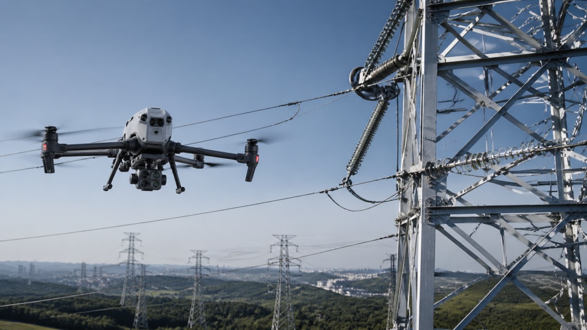
Extended endurance still matters, especially when inspection teams need to cover 8–15 transmission towers per sortie or maintain reserve power for return-to-home under headwind conditions. However, a 55-minute endurance claim under calm test conditions may deliver only 32–40 minutes of useful mission time once a custom payload, zoom gimbal, thermal camera, wind load, and battery reserve policy are applied in the field.
For line inspection, productive endurance is more important than nominal endurance. Productive endurance measures how much of a flight can be spent capturing stable, georeferenced, defect-detectable imagery. If a platform has long battery life but poor hover stability, weak gimbal isolation, or limited downlink resilience near substations, inspectors may collect less usable data than with a shorter-endurance aircraft engineered for mission accuracy.
A utility buyer should also separate corridor inspection, tower inspection, and emergency response. These are different use cases. Corridor work may prioritize 10–30 km route efficiency and repeatable waypoint automation. Tower-detail inspection may favor obstacle sensing, 20x–40x optical zoom, and centimeter-level position hold. Storm recovery often values fast deployment within 15 minutes, rugged transport, and stable operation in wind conditions of 10–12 m/s.
The most common procurement mistake is to compare airframes in isolation. A drone that appears efficient on paper can become expensive when its data pipeline requires manual file stitching, separate thermal analysis software, or repeated uploads across disconnected systems. For enterprise users, true performance should be evaluated across four layers: air platform, sensor suite, communication architecture, and software interoperability.
What utility teams should measure first
- Mission-ready endurance after payload integration, not laboratory endurance without inspection sensors.
- Hover accuracy and station-keeping stability near towers, especially when crosswind exceeds 7 m/s.
- Data link stability over typical operating ranges such as 2–8 km, including signal integrity near EMI-heavy assets.
- Defect detection workflow speed, from image capture to engineering review, typically targeted within 2–24 hours depending on urgency.
Key difference between brochure performance and field performance
Brochure performance usually reflects ideal payload, ideal weather, and ideal line of sight. Field performance reflects real tower spacing, vegetation clutter, terrain variation, thermal drift, battery aging after 150–250 cycles, and pilot workload. In a data-driven utility environment, the second number matters more because it aligns with maintenance planning, outage risk reduction, and fleet total cost of ownership.
Sensor fusion and payload architecture determine inspection quality
A custom drone for power line inspection earns its value through the quality of information it can extract from the asset. That usually requires more than a single visible-light camera. Utility teams increasingly combine RGB imaging, thermal sensing, LiDAR in selected corridor mapping cases, and precise GNSS or RTK inputs to produce inspection outputs that are actionable instead of merely visual.
Sensor fusion matters because many faults are not visible in one modality alone. A corroded fitting may appear in high-resolution optical imagery, while an overheating connector or abnormal load signature may appear first in thermal data. If the platform cannot synchronize these streams accurately, engineers lose the ability to compare defect type, location, severity, and maintenance priority in a single review workflow.
Payload architecture also affects endurance, stability, and serviceability. A dual-sensor pod weighing 800 g to 1.5 kg changes center of gravity, power draw, and gimbal response. If the aircraft was not designed around inspection payloads, operators may see vibration artifacts, shorter mission windows, or limited tilt angles that prevent clear views of insulators, spacers, clamps, and conductor attachment points.
For procurement teams, the practical question is whether the UAV can produce inspection-grade evidence at the required defect threshold. In many utility workflows, that means identifying cracks, flashover traces, thermal anomalies, hardware loosening, vegetation encroachment, and clearance issues without sending crews back for avoidable follow-up inspections.
Recommended payload evaluation criteria
The table below provides a practical framework for comparing payload architecture in utility inspection programs. It focuses on operational outcomes rather than generic marketing labels.
The main takeaway is that payload selection should start from defect taxonomy, not from camera marketing. Utilities should define what failure modes they want to detect, at what stand-off distance, under what environmental conditions, and with what downstream reporting requirement. Once those criteria are clear, airframe and payload trade-offs become easier to evaluate objectively.
A practical payload shortlist for different missions
- Routine tower inspection: stabilized RGB + thermal dual sensor, optical zoom, RTK option.
- Vegetation and clearance analysis: RGB + mapping workflow, optional LiDAR where canopy density is high.
- Post-storm rapid response: fast-deploy camera payload with wide-area situational imaging and reliable live link.
Data links, photogrammetry software, and fleet management drive scalable operations
Inspection quality does not end when the UAV lands. A utility-grade system must move data from aircraft to analysis environment with minimal friction. That is why stable communications, drone photogrammetry software compatibility, and uav fleet management system integration are central selection criteria. Without them, even high-quality imagery can become operationally expensive.
Data link resilience is especially important in transmission and substation environments, where electromagnetic interference, terrain masking, and long linear corridors can challenge command-and-control stability. A platform that performs well at 5 km in open terrain may degrade sharply around dense structures or uneven topography. Utilities should test link redundancy, fail-safe behavior, and live video quality under representative field conditions rather than generic range claims.
Software interoperability is another hidden differentiator. If image sets, thermal outputs, and flight logs cannot be moved efficiently into GIS, digital twin, work-order, or asset maintenance systems, the inspection program will rely on manual handling. That often adds 20–60 minutes of administrative work per mission and increases the risk of mislabeling, delayed maintenance, or incomplete traceability.
A scalable uav fleet management system helps utilities standardize battery health records, pilot currency, mission templates, firmware control, and aircraft utilization across multiple service regions. For organizations operating 10, 25, or 50 aircraft, this is no longer optional. It becomes a governance layer that reduces maintenance surprises and supports auditability for regulated infrastructure operations.
What enterprise software integration should look like
The following table compares software and data-management factors that often separate pilot projects from fleet-scale inspection programs.
The strongest programs are built around closed-loop information flow. Data is planned, captured, verified, processed, routed, reviewed, and converted into maintenance action without unnecessary manual transfer. That is where enterprise value appears: fewer repeat flights, shorter review cycles, more defensible asset decisions, and better utilization of field crews.
Warning signs of poor software fit
- Operators export data through 3 or more disconnected tools before engineering review.
- Battery history and maintenance records are stored manually in spreadsheets.
- Repeat inspections cannot align imagery to prior missions with acceptable positional consistency.
- Defect tags cannot be linked easily to asset IDs, work orders, or GIS layers.
Engineering criteria for procurement, deployment, and lifecycle cost control
Procurement teams evaluating a custom drone for power line inspection should look beyond acquisition price. The relevant financial unit is often cost per usable inspection output, not cost per aircraft. A lower-priced platform can become more expensive over 12–36 months if it requires extra pilots, more battery rotations, higher spare part consumption, or inefficient post-processing.
A structured sourcing process should examine at least six dimensions: payload suitability, communications robustness, software integration, maintainability, operator training burden, and support responsiveness. These factors affect deployment speed and service continuity. In utility operations, even a 24–48 hour delay in restoring inspection capability after equipment failure can influence outage planning and field scheduling.
Maintenance design is often underweighted in RFPs. Buyers should check battery replacement policy, expected cycle life, field-replaceable components, spare lead time, calibration requirements, and recommended service intervals. If a vendor cannot specify practical inspection, maintenance, and replacement workflows, lifecycle cost forecasting will remain uncertain.
Deployment readiness also depends on training and procedural standardization. A system that looks powerful in a demo may not scale well if new operators require weeks of highly manual setup. Utilities with multi-site operations should prefer platforms that support standard operating procedures, recurring mission templates, and clear acceptance criteria for data quality and aircraft health.
Procurement checklist for utility buyers
The table below can be used as a practical comparison tool during vendor screening, pilot validation, or final technical review.
The most effective procurement decision is usually the one that reduces uncertainty. A vendor or solution package should not only meet technical requirements, but also make maintenance effort, operating limits, data flow, and support obligations transparent. That aligns with TSV’s engineering-first view: parameters, tolerances, and process clarity matter more than broad performance claims.
A simple 5-step deployment model
- Define inspection objectives by asset class: tower hardware, conductor issues, thermal hotspots, vegetation, or emergency damage.
- Run a controlled field validation over 3–5 representative sites with real payloads and real reporting needs.
- Score results by defect detection quality, data transfer speed, operator workload, and repeatability.
- Integrate the chosen platform with photogrammetry, asset databases, and fleet management controls.
- Scale gradually with standard operating procedures, battery health monitoring, and periodic review of mission KPIs.
Common mistakes, field risks, and practical selection guidance
One frequent mistake is assuming that all utility inspections can be solved by one aircraft configuration. In reality, a platform optimized for long corridor patrols may not be ideal for close tower-detail imaging, and a compact rapid-response system may not deliver the data depth required for asset lifecycle analysis. Customization should therefore reflect mission mix, not just procurement preference.
Another risk is overestimating autonomy. Automated flight paths are useful, but utility environments still demand skilled human oversight. Towers, wires, birds, weather shifts, and local electromagnetic conditions create dynamic operating scenarios. Any fleet deployment plan should include operator competency checks, escalation procedures, and clear go/no-go thresholds such as wind, rain, visibility, and signal quality limits.
Buyers should also avoid treating thermal imaging as a universal answer. Thermal results depend on load condition, ambient temperature, emissivity assumptions, viewing angle, and inspection timing. Without a disciplined capture protocol, temperature anomalies can be missed or misinterpreted. This is why process design matters as much as sensor availability.
The most practical selection approach is to compare solutions against a defined inspection output. If the goal is to reduce repeat climbs by 30%, shorten post-flight review to under 12 hours, or build a multi-region fleet with centralized oversight, those performance targets should guide airframe choice, payload selection, software stack, and support model from the beginning.
FAQ: What utility teams ask before buying
How much flight time is enough for power line inspection?
For many utility missions, 30–45 minutes of productive endurance under real payload conditions is more valuable than a higher advertised number. Teams should define endurance after payload, reserve battery policy, and expected wind conditions. A drone with slightly lower nominal endurance but stronger stability and better data integration may deliver more usable inspections per day.
When is drone photogrammetry software necessary?
It becomes important when utilities need repeatable corridor models, asset context, geo-referenced defect records, or integration with GIS and engineering review. For simple visual checks, basic imaging may be enough. For structured inspection programs covering dozens or hundreds of assets, photogrammetry and standardized processing usually improve traceability and decision speed.
Why does a uav fleet management system matter for utilities?
Once a program grows beyond a few aircraft, fleet management becomes essential for battery cycle visibility, maintenance planning, pilot authorization, mission records, and firmware consistency. It supports operational control across multiple crews and reduces the chance of preventable downtime or undocumented maintenance gaps.
What should procurement teams request during evaluation?
They should request field validation with actual payloads, proof of software export paths, maintenance interval guidance, spare part lead times, training requirements, and examples of defect-reporting workflows. These details often reveal more about long-term suitability than headline specifications.
A custom drone for power line inspection should be selected as an engineered inspection system, not as a flying battery. Utilities that evaluate payload architecture, data link resilience, drone photogrammetry software compatibility, and uav fleet management system readiness are more likely to achieve safer inspections, cleaner datasets, and lower lifecycle friction. If your team is comparing platforms, refining technical requirements, or building a utility UAV sourcing roadmap, contact us to discuss a tailored evaluation framework and solution shortlist.
Search News
Hot Articles
- Carbon Fiber StructuresHow to Specify Aerospace Carbon Fiber Assemblies for Lightweight, Load-Bearing PartsJul 11, 2026
- Machine VisionXiaomi, Alibaba DAMO Academy Drive Open-Source Robotics Model Ecosystem, Lowering Algorithm Development Barriers for Overseas SMEs Adopting Chinese Robotics SolutionsMar 30, 2026
- Cobots & ArmsShanxi 'AI+' Conference Showcases Embodied Intelligence with Multinational Buyer Engagement: Key Industry ImplicationsMar 30, 2026
Popular Tags
Recommended News
 Jul 11, 2026How to Specify Aerospace Carbon Fiber Assemblies for Lightweight, Load-Bearing PartsAerospace carbon fiber assemblies: learn how to specify laminate design, load data, joining methods, and inspection controls for lighter, reliable load-bearing aerospace parts.Elena Rostova (UAV Systems Researcher)
 Mar 30, 2026Xiaomi, Alibaba DAMO Academy Drive Open-Source Robotics Model Ecosystem, Lowering Algorithm Development Barriers for Overseas SMEs Adopting Chinese Robotics SolutionsXiaomi & Alibaba DAMO Academy's open-source robotics models lower algorithm barriers for global SMEs. Boost efficiency in manufacturing, logistics & smart retail with ROS 2 compatible solutions.TSV Data Lab
 Mar 30, 2026Shanxi 'AI+' Conference Showcases Embodied Intelligence with Multinational Buyer Engagement: Key Industry ImplicationsShanxi 'AI+' Conference highlights embodied intelligence with Tesla, Ubtech & Jiantao showcasing multimodal robotics. 40+ global buyers validated tech on-site, creating new B2B channels for industrial automation & AI solutions.Chen Wei (Automation Lead Engineer)
 Mar 30, 2026Zhongguancun Unveils 6G Integrated Sensing-Computing-Intelligence Platform to Empower Embodied Robots for Global Industrial ApplicationsZhongguancun's new 6G platform revolutionizes industrial robotics with <10ms latency, empowering global automotive, logistics & port automation. Discover how this tech boosts China's smart manufacturing exports.TSV Data Lab
 Mar 30, 2026Mech-Mind Tianjin Embodied Intelligence R&D and Production Base Goes Live, Cutting Delivery Time by 20%–30% for Global Customized AMR+Vision SolutionsMech-Mind's Tianjin AMR+Vision production base cuts delivery time by 20%-30% for欧美 & Latin American markets. Discover how this PLd-certified facility accelerates customized robotics solutions for smart manufacturing and logistics.Chen Wei (Automation Lead Engineer)
 Mar 30, 2026Boao Forum Reveals 'Co-evolution of Big and Small Brains' Trend in Humanoid Robots, China's Embodied Intelligence Accelerates Adaptation to Overseas Manufacturing Service ScenariosDiscover how China's humanoid robots, featuring 'Co-evolution of Big and Small Brains,' are revolutionizing global manufacturing. Learn about Embodied Tian Gong 3.0's ISO compliance and overseas deployment at Boao Forum 2026.Chen Wei (Automation Lead Engineer)
 Mar 30, 2026China Railway Industrial Secures Patent for Embodied Robotics in Material Handling, Boosting High-Precision Delivery Capabilities for Overseas Infrastructure and Manufacturing ProjectsChina Railway Industrial's new patent for embodied robotics in material handling boosts high-precision delivery for global infrastructure & manufacturing. Discover how this innovation enhances logistics accuracy in automotive, rail transit & EPC projects.Chen Wei (Automation Lead Engineer)
 Oct 25, 2026Hesai Leads Global ADAS Main Lidar Shipments in Yole’s 2026 ReportHesai led global ADAS main lidar shipments with a 43% share in 2025, according to Yole’s 2026 report. Explore what this ranking reveals about its automotive market position.TSV Data Lab
 Oct 25, 2026Choosing an Aerospace Materials Manufacturer: Quality and Traceability ChecksChoosing an aerospace materials manufacturer? Learn how to verify certifications, test reports, and lot traceability to qualify suppliers confidently and reduce costly sourcing risks.Dr. Marcus Vance
 Oct 24, 2026Guotai Haitong: Global Entry-Level 3D Printer Shipments Rose 39% in Q1 2026Entry-level 3D printer shipments rose 39% in Q1 2026, Guotai Haitong reports. Explore how AI, multicolor printing and print farms are shaping market growth.Dr. Marcus Vance
 Oct 24, 2026Choosing an Industrial Vision Inspection Supplier: Acceptance Tests That MatterChoose an industrial vision inspection supplier with confidence. Discover acceptance tests for defect detection, false rejects, production speed, and reliable part rejection before you buy.TSV Data Lab
 Oct 23, 2026US Navy Raises Gecko Robotics Contract Ceiling to $300M for Robotic Fleet MaintenanceUS Navy raises Gecko Robotics’ contract ceiling to $300M for Pacific Fleet robotic inspections. Explore potential opportunities for maintenance suppliers and key procurement considerations.Chen Wei (Automation Lead Engineer)
 Oct 23, 2026Choosing Industrial Sensing Systems for Global Plants: Protocol CompatibilityCompare industrial sensing systems international buyers can trust. Explore protocol compatibility, reduce integration risks, and select proven configurations for reliable global plant deployments.TSV Data Lab
 Oct 22, 2026KUKA Showcases Physical AI and iiQKA.AI Vision at NVIDIA GTC BerlinExplore KUKA’s Physical AI showcase at NVIDIA GTC Berlin and discover how iiQKA.AI Vision aims to simplify robotic vision integration and improve 2D and 3D scene recognition.TSV Data Lab
 Oct 22, 2026Robotic Machining of Advanced Composites: What Tolerances Are Achievable?Explore advanced materials machining robotics: discover what drives achievable composite tolerances and how to validate accuracy before investing in your next machining system.Dr. Marcus Vance
 Oct 21, 2026China’s Industrial Robot Exports Near RMB 10 Billion in First Nine Months of 2026China’s industrial robot exports neared RMB 10 billion in January–September 2026, with value rising faster than volume. Explore the data and what it could mean for suppliers.Chen Wei (Automation Lead Engineer)
 Oct 21, 2026Low-Latency Industrial Data Processing: Pricing and Key Cost DriversExplore industrial data latency price drivers, from edge hardware to integration and support. Learn how to compare quotes, verify performance, and avoid unnecessary costs.TSV Data Lab
 Oct 20, 2026KUKA Launches iiQKA.AI Vision to Simplify Industrial Image ProcessingKUKA iiQKA.AI Vision simplifies industrial image processing with controller-based 2D and 3D vision. Explore drag-and-drop setup for vision-guided automation.TSV Data Lab
 Oct 20, 2026Smart Industrial Edge Devices: Key Criteria for Legacy PLC IntegrationChoose smart industrial edge devices for legacy PLC integration. Discover key criteria for compatibility, data quality, security, and reliable collection without disrupting control.TSV Data Lab
 Oct 19, 2026Choosing a Radar Sensor by Application: Range, Resolution, and Field of ViewSimplify radar sensor application based product selection. Compare range, resolution, and field of view to avoid blind spots and choose with confidence. Explore the guide.TSV Data Lab
 Oct 18, 2026Comparing Material Options for Procurement: Specs, Costs, and Supply RisksExplore procurement oriented technical content on material options, specs, costs, and supply risks. Compare alternatives to cut hidden expenses and make confident sourcing decisions.Dr. Marcus Vance
 Oct 17, 20265-Axis CNC Positioning Accuracy: How to Interpret ISO 230-2 Test ResultsAssess 5 axis CNC machining positioning accuracy with ISO 230-2. Learn to interpret repeatability, reversal error, and test conditions to compare suppliers and make confident acceptance decisions.Dr. Marcus Vance
 Oct 16, 2026Choosing a Rugged Edge AI Box Supplier: Thermal Tests and Lifecycle SupportChoose a rugged edge AI box supplier with proven thermal performance and reliable lifecycle support. Discover the tests and commitments to verify before you buy.TSV Data Lab
 Oct 15, 2026R&D Cost Reduction Services: How to Evaluate Fees, Savings, and ROIEvaluate R&D cost reduction services with confidence. Compare fees, verify savings, and calculate ROI without compromising performance. Discover how to choose a provider that delivers real value.Chen Wei (Automation Lead Engineer)