When Solid-State LiDAR Point Cloud Density Becomes a Bottleneck
Publication Date
author
As autonomous systems scale across factories, warehouses, mobile robots, and aerial platforms, solid-state LiDAR point cloud density is shifting from a marketing spec to an engineering constraint. For teams comparing sensors for robotics navigation, solid-state LiDAR range accuracy, AGV AMR obstacle avoidance systems, and machine vision 3D measurement systems, the practical issue is simple: if the cloud is too sparse, the system may still “see” an object—but not with enough spatial detail to classify it correctly, estimate distance reliably, or act safely in time. In many deployments, that is where performance breaks down.
The key takeaway is that point cloud density becomes a bottleneck when application demands outpace the sensor’s ability to provide enough usable returns per frame, per square meter, and per target at the required range and speed. This affects not only perception quality, but also downstream costs in software tuning, false alarm management, validation cycles, and safety margins. For buyers and engineering teams, the right question is not “What is the LiDAR resolution on paper?” but “At my operating distance, target size, reflectivity, vibration level, and vehicle speed, do I still get enough points to make a reliable decision?”
When does solid-state LiDAR point cloud density actually become the bottleneck?
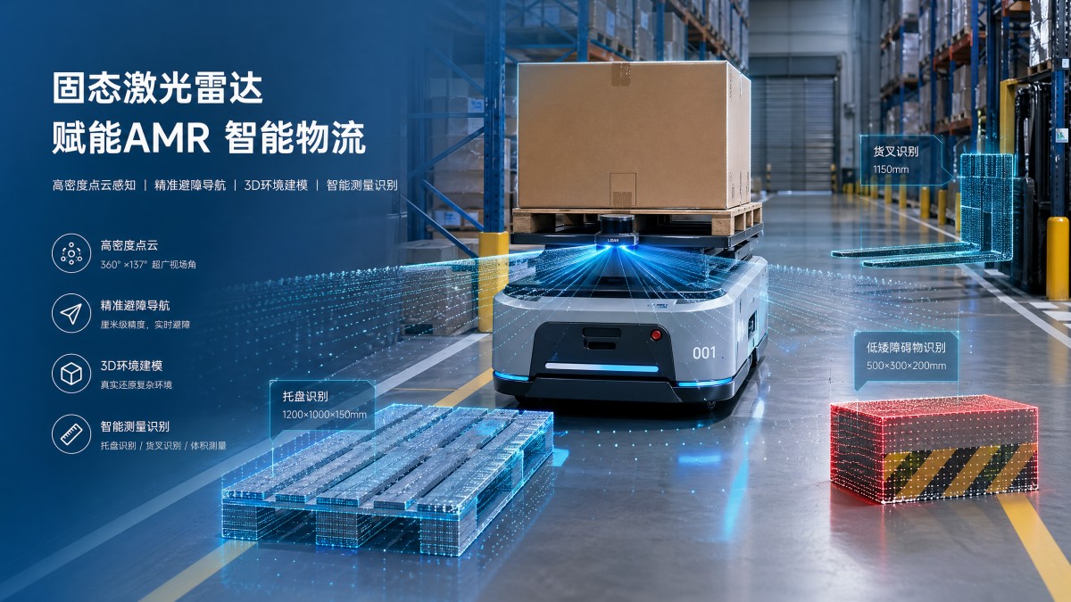
Point cloud density becomes the bottleneck when the sensor no longer supplies enough spatial samples for the task being performed. This usually appears in four situations:
- Longer operating distances: as distance increases, the angular spacing between beams translates into larger gaps on the target surface.
- Small or low-profile obstacles: pallets, forks, cables, low cartons, thin poles, and irregular edges may only receive a few returns.
- Higher vehicle or robot speeds: the system has less time to observe and confirm objects across multiple frames.
- Complex industrial environments: reflective metal, dust, dark materials, mixed lighting, and partial occlusion reduce usable returns.
In theory, a sensor may still detect presence. In practice, sparse data can create failure modes that matter more than outright blindness: unstable object contours, poor segmentation, inconsistent free-space mapping, inaccurate edge detection, and unreliable tracking. For an AMR, that may mean hesitation, unnecessary stopping, or late braking. For a 3D measurement workflow, it may mean incomplete surfaces and reduced dimensional confidence. For procurement teams, sparse data often turns into hidden integration cost.
This is why density must be treated as a task-level performance metric, not just a spec-sheet feature.
Why headline specs often fail to predict real-world performance
Many teams evaluate LiDAR using headline claims such as channels, frame rate, field of view, or maximum range. These matter, but none of them alone tells you whether the sensor delivers enough actionable point density in your use case.
The common gap is that raw specifications do not capture effective point cloud density under operational conditions. A sensor may advertise long range, but if only a small number of returns land on a low-reflectivity object at that distance, the object is not truly measurable in a robust way. Likewise, a wide field of view is helpful, but if available points are spread too thinly over that field, local detail suffers.
Decision-makers should push beyond generic language and ask for measurable performance under defined conditions:
- Points per square meter at 5 m, 10 m, 20 m, and 30 m
- Minimum detectable object size at specific distances
- Performance on black, gray, metallic, and mixed-material targets
- Point stability under vibration, dust, and motion blur conditions
- Density retention at edge-of-FOV positions, not just centerline targets
For technical buyers, this is the difference between buying a sensor and buying a validated perception capability.
How low point cloud density affects robotics navigation and obstacle avoidance
In AGV AMR obstacle avoidance systems, density directly influences whether the navigation stack can distinguish traversable space from risk. If the cloud is sparse, the robot may still detect a large wall, but struggle with partial obstacles such as open pallet gaps, hanging straps, protruding forks, or low-lying items.
The operational consequences are usually one of three patterns:
- Conservative behavior: the robot slows too often, reroutes unnecessarily, or stops for uncertain detections.
- Late confidence: the robot needs multiple frames before classification is stable, increasing braking distance requirements.
- Detection inconsistency: obstacle presence appears and disappears frame to frame, creating unstable planning behavior.
This matters especially in dynamic environments where forklifts, personnel, carts, and shelving edges overlap in the same field of view. Sparse clouds make it harder for perception software to maintain reliable object contours. The result is not always a crash scenario; often it is lower throughput, reduced fleet efficiency, and more engineering effort spent compensating for sensor limitations with algorithmic filtering.
For operations leaders, that means lower effective productivity. For engineers, it means more tuning. For procurement, it means a lower-cost sensor may trigger a higher total system cost.
How density limits solid-state LiDAR range accuracy and measurement confidence
Solid-state LiDAR range accuracy is often discussed as a standalone metric, but in real systems it interacts with density. Even if per-point ranging precision is acceptable, low point density can still reduce measurement confidence because there are too few samples to define a surface robustly.
This is particularly important in:
- Docking and alignment tasks
- Edge and corner detection
- Volume estimation and 3D profiling
- Machine vision 3D measurement systems
For example, a flat target measured with many stable returns allows averaging, outlier rejection, and surface fitting. The same target measured with only a few points may produce unstable plane estimation, especially when the target is angled, partially reflective, or moving. In other words, density does not just improve appearance of the point cloud; it improves statistical confidence in geometric interpretation.
That is why engineering teams should assess not only nominal range accuracy in millimeters, but also whether enough points are available to support the measurement method used downstream.
What target readers should evaluate before selecting a solid-state LiDAR
Different stakeholders care about different failure modes, but all should align around the same evaluation framework.
For R&D and system engineers:
- Map required object sizes to actual operating distances
- Calculate expected point spacing on target surfaces
- Test reflectivity extremes and angular incidence effects
- Measure detection stability across multiple frames during motion
- Validate in cluttered and partially occluded scenes, not only lab setups
For operators and deployment teams:
- Track false stop frequency and near-miss behaviors
- Observe performance in dust, vibration, and mixed lighting
- Review maintenance burden caused by sensitivity drift or contamination
- Check whether sensor performance degrades at aisle edges and corners
For procurement and enterprise decision-makers:
- Request benchmark data, not marketing summaries
- Compare usable density in the intended application zone, not only max range
- Estimate integration cost if software must compensate for sparse returns
- Assess whether safety margins reduce throughput enough to affect ROI
- Consider lifecycle risk: firmware maturity, supply continuity, calibration support
The best buying decision often comes from a simple principle: evaluate the sensor at the exact edge cases where your system cannot tolerate uncertainty.
How to test whether point cloud density is sufficient for your application
A useful evaluation method is to define acceptance criteria around task performance rather than general image quality. Instead of asking whether the cloud “looks dense enough,” ask whether it enables repeatable decisions.
A practical test plan should include:
- Distance ladder testing: validate performance at increasing range intervals relevant to stopping distance or measurement volume.
- Target diversity: include dark objects, reflective metal, low-height obstacles, mesh-like structures, and irregular shapes.
- Motion scenarios: test both sensor motion and object motion, because frame-to-frame continuity often matters more than static density.
- Environment stress: add dust, vibration, ambient light variation, and partial occlusion where applicable.
- Decision metrics: evaluate detection probability, point count on target, contour completeness, false positives, tracking stability, and reaction timing.
This approach helps separate “sensor visibility” from “system usability.” A sensor may show occasional target hits while still failing to support dependable control logic.
Where higher density is worth paying for—and where it may not be
Not every deployment needs the highest possible density. The value depends on task complexity, safety criticality, and the cost of uncertainty.
Higher density is usually worth the investment when:
- The system must detect small or low-contrast obstacles
- Vehicle speeds leave little time for multi-frame confirmation
- Navigation occurs in mixed traffic or human-shared environments
- 3D measurement quality directly affects downstream process accuracy
- Downtime, false stops, or qualification errors carry high operational cost
Moderate density may be sufficient when:
- Objects are large, structured, and highly visible
- Operating speed is low
- The sensor serves as one layer in a fused perception stack
- The environment is controlled and low-clutter
For management teams, this becomes an ROI question. Paying more for density makes sense when it reduces engineering rework, improves fleet throughput, lowers safety validation burden, or expands operating conditions. If it only improves visual richness without changing system decisions, the return may be limited.
Final assessment: point cloud density is now a system-level purchasing criterion
When solid-state LiDAR point cloud density becomes a bottleneck, the issue is rarely isolated to the sensor itself. It cascades through perception reliability, braking logic, false-stop rates, software complexity, validation effort, and operational efficiency. That is why density should be treated as a system-level purchasing criterion, especially in robotics navigation, AGV AMR obstacle avoidance systems, solid-state LiDAR range accuracy validation, and machine vision 3D measurement systems.
The most practical conclusion is clear: do not judge LiDAR by abstract specs alone. Judge it by how many usable points it delivers on the targets that matter, at the distances that matter, under the conditions that matter. In hard-tech deployment, sparse data does not merely reduce image quality—it limits decision quality. And once decision quality is constrained, point cloud density is no longer a feature. It is the bottleneck.
Search News
Hot Articles
- Carbon Fiber StructuresHow to Specify Aerospace Carbon Fiber Assemblies for Lightweight, Load-Bearing PartsJul 11, 2026
- Machine VisionXiaomi, Alibaba DAMO Academy Drive Open-Source Robotics Model Ecosystem, Lowering Algorithm Development Barriers for Overseas SMEs Adopting Chinese Robotics SolutionsMar 30, 2026
- Cobots & ArmsShanxi 'AI+' Conference Showcases Embodied Intelligence with Multinational Buyer Engagement: Key Industry ImplicationsMar 30, 2026
Popular Tags
Recommended News
 Jul 11, 2026How to Specify Aerospace Carbon Fiber Assemblies for Lightweight, Load-Bearing PartsAerospace carbon fiber assemblies: learn how to specify laminate design, load data, joining methods, and inspection controls for lighter, reliable load-bearing aerospace parts.Elena Rostova (UAV Systems Researcher)
 Mar 30, 2026Xiaomi, Alibaba DAMO Academy Drive Open-Source Robotics Model Ecosystem, Lowering Algorithm Development Barriers for Overseas SMEs Adopting Chinese Robotics SolutionsXiaomi & Alibaba DAMO Academy's open-source robotics models lower algorithm barriers for global SMEs. Boost efficiency in manufacturing, logistics & smart retail with ROS 2 compatible solutions.TSV Data Lab
 Mar 30, 2026Shanxi 'AI+' Conference Showcases Embodied Intelligence with Multinational Buyer Engagement: Key Industry ImplicationsShanxi 'AI+' Conference highlights embodied intelligence with Tesla, Ubtech & Jiantao showcasing multimodal robotics. 40+ global buyers validated tech on-site, creating new B2B channels for industrial automation & AI solutions.Chen Wei (Automation Lead Engineer)
 Mar 30, 2026Zhongguancun Unveils 6G Integrated Sensing-Computing-Intelligence Platform to Empower Embodied Robots for Global Industrial ApplicationsZhongguancun's new 6G platform revolutionizes industrial robotics with <10ms latency, empowering global automotive, logistics & port automation. Discover how this tech boosts China's smart manufacturing exports.TSV Data Lab
 Mar 30, 2026Mech-Mind Tianjin Embodied Intelligence R&D and Production Base Goes Live, Cutting Delivery Time by 20%–30% for Global Customized AMR+Vision SolutionsMech-Mind's Tianjin AMR+Vision production base cuts delivery time by 20%-30% for欧美 & Latin American markets. Discover how this PLd-certified facility accelerates customized robotics solutions for smart manufacturing and logistics.Chen Wei (Automation Lead Engineer)
 Mar 30, 2026Boao Forum Reveals 'Co-evolution of Big and Small Brains' Trend in Humanoid Robots, China's Embodied Intelligence Accelerates Adaptation to Overseas Manufacturing Service ScenariosDiscover how China's humanoid robots, featuring 'Co-evolution of Big and Small Brains,' are revolutionizing global manufacturing. Learn about Embodied Tian Gong 3.0's ISO compliance and overseas deployment at Boao Forum 2026.Chen Wei (Automation Lead Engineer)
 Mar 30, 2026China Railway Industrial Secures Patent for Embodied Robotics in Material Handling, Boosting High-Precision Delivery Capabilities for Overseas Infrastructure and Manufacturing ProjectsChina Railway Industrial's new patent for embodied robotics in material handling boosts high-precision delivery for global infrastructure & manufacturing. Discover how this innovation enhances logistics accuracy in automotive, rail transit & EPC projects.Chen Wei (Automation Lead Engineer)
 Oct 25, 2026Hesai Leads Global ADAS Main Lidar Shipments in Yole’s 2026 ReportHesai led global ADAS main lidar shipments with a 43% share in 2025, according to Yole’s 2026 report. Explore what this ranking reveals about its automotive market position.TSV Data Lab
 Oct 25, 2026Choosing an Aerospace Materials Manufacturer: Quality and Traceability ChecksChoosing an aerospace materials manufacturer? Learn how to verify certifications, test reports, and lot traceability to qualify suppliers confidently and reduce costly sourcing risks.Dr. Marcus Vance
 Oct 24, 2026Guotai Haitong: Global Entry-Level 3D Printer Shipments Rose 39% in Q1 2026Entry-level 3D printer shipments rose 39% in Q1 2026, Guotai Haitong reports. Explore how AI, multicolor printing and print farms are shaping market growth.Dr. Marcus Vance
 Oct 24, 2026Choosing an Industrial Vision Inspection Supplier: Acceptance Tests That MatterChoose an industrial vision inspection supplier with confidence. Discover acceptance tests for defect detection, false rejects, production speed, and reliable part rejection before you buy.TSV Data Lab
 Oct 23, 2026US Navy Raises Gecko Robotics Contract Ceiling to $300M for Robotic Fleet MaintenanceUS Navy raises Gecko Robotics’ contract ceiling to $300M for Pacific Fleet robotic inspections. Explore potential opportunities for maintenance suppliers and key procurement considerations.Chen Wei (Automation Lead Engineer)
 Oct 23, 2026Choosing Industrial Sensing Systems for Global Plants: Protocol CompatibilityCompare industrial sensing systems international buyers can trust. Explore protocol compatibility, reduce integration risks, and select proven configurations for reliable global plant deployments.TSV Data Lab
 Oct 22, 2026KUKA Showcases Physical AI and iiQKA.AI Vision at NVIDIA GTC BerlinExplore KUKA’s Physical AI showcase at NVIDIA GTC Berlin and discover how iiQKA.AI Vision aims to simplify robotic vision integration and improve 2D and 3D scene recognition.TSV Data Lab
 Oct 22, 2026Robotic Machining of Advanced Composites: What Tolerances Are Achievable?Explore advanced materials machining robotics: discover what drives achievable composite tolerances and how to validate accuracy before investing in your next machining system.Dr. Marcus Vance
 Oct 21, 2026China’s Industrial Robot Exports Near RMB 10 Billion in First Nine Months of 2026China’s industrial robot exports neared RMB 10 billion in January–September 2026, with value rising faster than volume. Explore the data and what it could mean for suppliers.Chen Wei (Automation Lead Engineer)
 Oct 21, 2026Low-Latency Industrial Data Processing: Pricing and Key Cost DriversExplore industrial data latency price drivers, from edge hardware to integration and support. Learn how to compare quotes, verify performance, and avoid unnecessary costs.TSV Data Lab
 Oct 20, 2026KUKA Launches iiQKA.AI Vision to Simplify Industrial Image ProcessingKUKA iiQKA.AI Vision simplifies industrial image processing with controller-based 2D and 3D vision. Explore drag-and-drop setup for vision-guided automation.TSV Data Lab
 Oct 20, 2026Smart Industrial Edge Devices: Key Criteria for Legacy PLC IntegrationChoose smart industrial edge devices for legacy PLC integration. Discover key criteria for compatibility, data quality, security, and reliable collection without disrupting control.TSV Data Lab
 Oct 19, 2026Choosing a Radar Sensor by Application: Range, Resolution, and Field of ViewSimplify radar sensor application based product selection. Compare range, resolution, and field of view to avoid blind spots and choose with confidence. Explore the guide.TSV Data Lab
 Oct 18, 2026Comparing Material Options for Procurement: Specs, Costs, and Supply RisksExplore procurement oriented technical content on material options, specs, costs, and supply risks. Compare alternatives to cut hidden expenses and make confident sourcing decisions.Dr. Marcus Vance
 Oct 17, 20265-Axis CNC Positioning Accuracy: How to Interpret ISO 230-2 Test ResultsAssess 5 axis CNC machining positioning accuracy with ISO 230-2. Learn to interpret repeatability, reversal error, and test conditions to compare suppliers and make confident acceptance decisions.Dr. Marcus Vance
 Oct 16, 2026Choosing a Rugged Edge AI Box Supplier: Thermal Tests and Lifecycle SupportChoose a rugged edge AI box supplier with proven thermal performance and reliable lifecycle support. Discover the tests and commitments to verify before you buy.TSV Data Lab
 Oct 15, 2026R&D Cost Reduction Services: How to Evaluate Fees, Savings, and ROIEvaluate R&D cost reduction services with confidence. Compare fees, verify savings, and calculate ROI without compromising performance. Discover how to choose a provider that delivers real value.Chen Wei (Automation Lead Engineer)